|
||

|

|
|

|
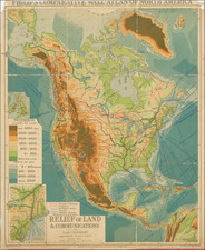
Fascinating composite of maps of North America, South America and three river systems in America, which appeared in Johnston's Physical Atlas.
The map is color coded to show the wider regions into which various rivers systems drain.
The explanatory note states:
In this Map . . . the areas of the River Basins are stated in Geographical Square Miles, and each is compared with. that of the R.Pregel (Prussia) which is reckoned = 1.; nearly corresponding with this is the Basin of the R. Motagua, one of the principal streams in Central America, the extent of which is 7,040, while that of the Pregel is 5,920 Sq. Miles. The figures placed over the name of a Basin show the extent of its surface in square miles, and those under it, its extent as compared with the Pregel For example, the Basin of the Orinoco is 252,000 Square Miles in extent, and 42 times greater than that of the Pregel. The greater part of these figures can only be considered as an approximation to the truth.

![(South Atlantic) Nieuwe Wassende Graadige Pas-kaart van de Kust van Guinea en Brasilia strekkende van Cap Verde tot de Cap de Bon-Esperance en Verders van Rio de Berbice tot Rio de la Plata. [New Increasing Latitude Sea Chart of the Coast of Guinea and Brazil stretching from Cape Verde to the Cape of Good Hope and Further from the Berbice River to the Rio de la Plata.]](https://storage.googleapis.com/raremaps/img/small/99819.jpg)