|
||

|

|
|

|
Stock# 102757
Description
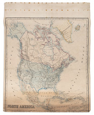
Large map of North America, offering a detailed cartographic representation of the landscape and communications of North America.
The map employs a color-coded system to distinguish between land heights and sea depths. Additionally, there is a systemt to distinguish different lines of transit.
There is an inset map in the lower lefthand corner that details the shipping and railway routes through New York. An additional inset map in the center of the lefthand side details the UK and some principal railway and canal routes.
The map also details steamer routes, principal sea and inland ports. These elements underscore the importance of maritime trade and transport in the economic structure of the continent.
Condition Description
Large color map printed on 20th-century wove paper. Signs of wear at previous folds. Some loss at top title as shown.
![[ Sea of the West ] L'Amerique Septentrionale divisee en ses principaux Etats . . . 1782](https://storage.googleapis.com/raremaps/img/small/80228.jpg)
![[Hand Drawn Map] Le Golfe de Mexique avec les Pays Circonvoisins](https://storage.googleapis.com/raremaps/img/small/91580.jpg)