|
||

|

|
|

|
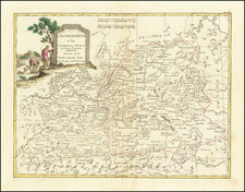
The map provides a detailed representation of a portion of the Castile region in Spain, focusing specifically on the provinces of Cuenca and Guadalajara.
Towns & Cities:
-
Cuenca: The capital city of the Cuenca province, it is famously known for its "Hanging Houses", precariously positioned on the edge of tall cliffs. Historically, it has seen the confluence of Christian, Muslim, and Jewish cultures, evident in its architecture and cultural artifacts.
-
Guadalajara: As the capital of its namesake province, Guadalajara has a rich history dating back to Roman times. The city has witnessed numerous battles and has an array of historical structures, including the impressive Mendoza Palace and the Santa María la Mayor Church.
-
Segovia: Though situated a bit northwest of the main focus of the map, Segovia is an essential city in the broader Castile region. Renowned for its Roman aqueduct, Gothic cathedral, and Alcázar, it serves as a testament to the myriad cultures that once thrived here.
The Castile region has been a significant part of Spain's historical narrative. Its roots trace back to the Roman era, after which it saw a prolonged period of Muslim rule. The Reconquista, a series of campaigns by the Christians to reclaim territory taken by the Moors, played a pivotal role in shaping the region, especially cities like Cuenca and Guadalajara.
Throughout the Middle Ages, these towns and cities grew in strategic and cultural importance, becoming centers of trade, education, and art. The blend of Moorish and Christian architectural styles, as well as Jewish influences, lends the region a unique cultural and historical flavor.
The map, by detailing roads, would have been invaluable in connecting these towns, facilitating trade, pilgrimage, and military expeditions. Given that it is based on the work of Tomás López, a renowned Spanish cartographer from the 18th century, it would reflect the meticulousness and attention to detail characteristic of his works.
Homann Heirs was a German publishing firm that enjoyed a major place in the European map market throughout the eighteenth century. Founded in 1702 by Johann Baptist Homann, the business passed to his son, Christoph, upon Johann’s death in 1724. Christoph died in 1730, aged only 27, and the firm was inherited by subsequent Homann heirs. This altered the name of the company, which was known as Homann Erben, or Homann heirs. The firm continued in business until 1848.
Tomás López de Vargas Machuca (1730-1802) was one of Spain’s most prominent cartographers in the eighteenth century. He was born in Toledo but studied at the Colegio Imperial in Madrid, where he focused on mathematics, grammar, and rhetoric. Along with a small group of colleagues, in 1752 the Spanish government sent López for training in Paris with the renowned geographer Jean Baptiste Bourguignon d’Anville. When he returned to Spain he was named Geógrafo de los dominios de Su Magestad and put in charge of the geographic collections of Charles III. He published many maps, including his fascinating maps of the Americas, and a variety of geography manuals. Some of his most famous maps are of the Iberian Peninsula, part of his large project to create a majestic atlas of Spain. Unfinished in his lifetime, López's children published the Atlas Geográfico de España (Geographical Atlas of Spain) in 1804. It was republished in 1810 and 1830.
![(City Views - World and Iberian Peninsula) Illustriorum Hispaniae Urbium Tabulae, cum Appendice Celebriorum Alibi aut olim aut nunc Parentium HIspanis, Aut euroum Civitatum Commerciis florentium. [Maps of the Most Famous Cities in Spain, with an Appendix of Other Notable Cities, Either Formerly or Currently Associated with Spain, or Prominent in the Trade of European Cities.]](https://storage.googleapis.com/raremaps/img/small/94019.jpg)
![[Bay of Biscay] Paskaerte Vande Bocht van Vranckrijck Biscajen en Galissen tuscchen Heylant en C. de Finisterre](https://storage.googleapis.com/raremaps/img/small/83967.jpg)