|
||

|

|
|

|
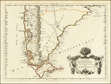
Fine early regional map, centered on the lower part of the Rio de la Plata.
The map shows parts of Argentina and Uruguay with many named settlements, rivers, islands, and ports. Further into the interior, Peru and Tucuman (present-day Argentina) are shown, as are the proposed courses of rivers, mountains, and settlement locations. The inland detail offers an intriguing glimpse into the European knowledge of the region.
This map is part of the Nuremberg edition of Du Val's atlas, Le Monde Terreste, ou la Geographie Universelle, which initially appeared in Paris in 1660.
During the 17th century, cartography became an increasingly refined discipline, with Pierre Du Val's atlases gaining recognition for their detail and accuracy. Du Val's original atlas was translated into German version Johann Christoff Beer in 1678 and by Johann Hoffmann in 1681.
The higher plate number used for this 1681 map differentiates it from its 1678 predecessor.
Pierre Duval (1618-1683) was a French geographer, cartographer, and publisher who worked in Abbeville and Paris during the seventeenth century. He was born in the former city, in northeast France, before moving to Paris. Duval was the nephew of the famous cartographer Nicolas Sanson, from whom he learned the mapmaker's art and skills. Both men worked at the royal court, having followed the royal request for artists to relocate to Paris. In addition to numerous maps and atlases, Du Val's opus also includes geography texts. He held the title of geographe ordinaire du roi from 1650 and died in 1683, when his wife and daughters took over his business.
![[Falkland Islands] Carta delle Isole Malouine Dette dagl'Inglesi Isole Falkland](https://storage.googleapis.com/raremaps/img/small/91880.jpg)