|
||

|

|
|

|
Through the Straits of Magellan or Round the Horn
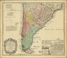
Detailed map of the Straits of Magellan and the southernmost part of South America by Guillaume Sanson, member of the most important French mapmaking family of the seventeenth century.
Sanson's map of the region was the first detailed map of the southern part of South America to appear in a French atlas. The map is remarkably detailed for the period and reflects the most up-to-date information brought back to Paris from foreign and Jesuit sources.
The map features the Terre Magellanique, which encompasses what is today Argentina and Chile. The Andes form a prominent spine down the length of the landmass. There are several Spanish settlements on the Chilean side of the continent; the Magellanique side is far less settled, a vast expanse with a few rivers and large open spaces.
To the west is the island of Chiloé (here Chilue), with its capital of Castro marked. This example also includes a manuscript addition of “P. del Arco” in the northwest corner of the island. When the Spanish first saw the island in 1540, they found it inhabited by the Chono, Huilliche, and Cunco peoples. For much of the Spanish colonial period, and when this map was made, the island was near the southernmost boundary of Spanish settlement in Chile; south of the dotted line shown here was the territory of the Indigenous peoples who fiercely defended their autonomy and land.
Chiloé is today Chile’s second largest island. The largest is the big island of Tierra del Fuego. However, the precise outline of Tierra del Fuego is left undefined here—exploration of the straits and waterways of this archipelago would continue well into the twentieth century.
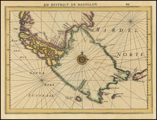
Early exploration of the Straits of Magellan and Tierra del Fuego
The first European to pass through the strait that leads to the Pacific was Ferdinand Magellan during the first circumnavigation (1519-1522). Magellan died in the Philippines, but his legacy lived on in the geographic features named for him, the straits, and the names he gave to the area, such as Patagonia, a reference to the giant people he supposedly saw there.
Magellan’s geographic encounter was important to European commerce and geography, but there were relatively few ships that actually made the arduous journey through the passage. In 1553, García Jofré de Loaiza became the second navigator to pass the straits and found Tierra del Fuego to be an island. In 1558, Juan Ladrillero led the first west-east crossing of the waterway. The Spanish declared it part of their imperial holdings, while the Dutch East India Company (VOC) thought it fell under the parameters of their charter.
In 1578, English buccaneer Francis Drake used the strait to reach the Spanish colonies in western South America. In response, the Spanish attempted to colonize the straits; such efforts ended in disaster for the would-be settlers. When Englishman Thomas Cavendish passed by in 1587, he found only ruins and named the site Port Famine. On this map it is labeled Citta de S. Phelippe ats P Famine.
In the seventeenth century, European traders longed for another way to access the Pacific that was not under the control of the Spanish or the VOC. Dutchmen Schouten and Le Maire took action in 1615, finding an alternative passage around Cape Horn, and via an eastern trait between Tierra del Fuego and Staten Land now named for Le Maire. Henceforth, most traffic in the area would round the Horn rather than attempt the Straits. However, both options were dangerous and grueling to navigate.
The son of famous French cartographer Nicolas Sanson, Guillaume (1633-1703) carried on his father's work. Like his sire, he was a court geographer to Louis XIV. He often worked in partnership with another prominent cartographer of the time, Hubert Jaillot.
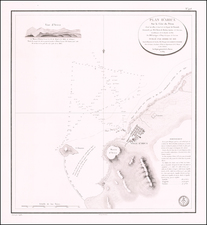
![Segundo Plano de Varios Puertos Del Estrecho de Magallanes, Levantados El Ano De 1786 [Second Plan of Various Ports of the Strait of Magellan, Surveyed in the Year 1786.]](https://storage.googleapis.com/raremaps/img/small/92297.jpg)