|
||

|

|
|

|
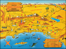
Street Map Lake Elsinore Valley, California, by cartographer J. R. Williams and published by the Lake Elsinore Valley Sun on January 1st, 1953, offers a detailed representation of the Lake Elsinore Valley in Southern California. This map delineates the region's intricate urban layout, showcasing key streets, landmarks, and institutions in the thriving mid-20th-century community.
Lake Elsinore Valley, nestled within the broader Southern California landscape, was a region in the throes of post-war growth during the 1950s. America's mid-century boom, fueled by the economic prosperity of the post-WWII era and the growing ubiquity of the automobile, led to an increased suburban expansion, especially in California. This map captures the essence of that era, detailing the infrastructure and community focal points that became integral to the valley's burgeoning population.
This piece provides an expansive view of the community's organization, offering references to both religious institutions and civic establishments. Featured are various churches, from the First Baptist Church on Grand Avenue to the Seventh-day Adventist Church on Kellogg, showcasing the rich religious tapestry of the community. Concurrently, civic landmarks such as the Elsinore Union High School, the Fire & Police City Hall, and the Greyhound Bus Terminal illustrate the services and communal centers that anchored the residents of Lake Elsinore Valley.
Geographically, the map offers clarity on the region's orientation, establishing Graham Avenue as the dividing line between North and South, and Main Street as the demarcation between East and West. The detailing of street numbering systems on the South Side of Lake Elsinore, starting on Grand Avenue at Machado Street, demonstrates the practical utility of the map for residents and visitors alike.
Furthermore, the map provides context about Lake Elsinore Valley's position within Southern California. With references to major cities like Los Angeles, Palm Springs, and San Diego, it situates the valley as a strategic point within the broader Californian network, emphasizing its connectedness and relevance. The mention of "Compliments of Lake Elsinore Valley Chamber of Commerce" suggests that this map, beyond its utilitarian purposes, was also a promotional tool, likely aimed at drawing visitors or potential residents to the valley during a period of significant growth.