|
||

|

|
|

|
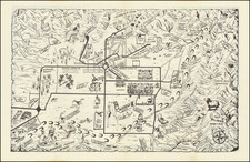
Map of Kings County California, published by C.F. Weber Co. in San Francisco and Los Angeles, and copyrighted in 1914 by the Punnett Brothers, provides a comprehensive depiction of Kings County at the dawn of the 20th century. Notably, the map delineates the paved highways, roads, railroads, electric lines, cities, towns, waterways, and other pertinent geographical features, indicative of the region's burgeoning infrastructure and development.
The early 20th century was a transformative time for California. It was a period marked by rapid population growth, agricultural expansion, and the rise of the state as an economic powerhouse. Kings County, nestled in the San Joaquin Valley, was no exception to these broader trends. Agriculture, especially, had taken firm root in the county, benefitting from the state's favorable climate and the innovations in irrigation and farming practices. This map captures the intricate web of transportation and communication lines that underpinned the county's socio-economic growth.
The mention of "paved highways" and "electric lines" on the map is particularly indicative of the advancements of the era. With the rise of the automobile, paving roads became an imperative, connecting remote areas with urban centers and boosting local economies. Likewise, the advent of electric lines signaled the spread of modern amenities and the increasing electrification of the West Coast.
Railroads, highlighted prominently in the map, played a pivotal role in the county's growth, facilitating trade, and movement. These rail links, some of the main arteries of California's vast railway network, further integrated Kings County into the larger Californian and national economies.
The issuance of this map by the "Progressive Map Service" in collaboration with engineers and designers like Dan W. Chamberlin of Fresno underscores the commercial and developmental significance maps held at the time. Such detailed cartographic resources, beyond mere tools of navigation, also functioned as symbols of progress, offering insights into the ambitions and visions of those who sought to shape the future of regions like Kings County.
![(Coachella Valley, California) Check in at Indio Hub of the California Desert Playground [cover title]](https://storage.googleapis.com/raremaps/img/small/97327.jpg)