|
||

|

|
|

|
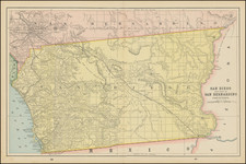
Nice example of this detailed map of Sutter County, providing a comprehensive overview of Sutter County's geography and infrastructural developments.
Crafted meticulously from the latest official and private sources of its time, the blue line print was not just a navigational tool but a reflection of the county's rich history and burgeoning progress.
The map distinctly delineated the vast ranchos, a legacy of the Spanish and Mexican land grants. Townships indicated growing settlements and communities. Roads, railroads, and trails were markers of connectivity, with railroads being evidence of the county's integration into the broader Californian economy. Natural water bodies like creeks, levees, and rivers underscored the county's riparian richness, while sinks and basins highlighted its unique topographical features.
History of Sutter County
Sutter County's Origins: Established in 1850, Sutter County is named after Captain John Sutter, an immigrant from Switzerland who was granted a large tract of land by the Mexican government. He established the New Helvetia settlement, which would become pivotal in California's history. John Sutter's sawmill in neighboring El Dorado County was the site of the discovery of gold in 1848, marking the onset of the California Gold Rush. While the gold was not found directly in Sutter County, the region was significantly impacted. Its waterways and lands became thoroughfares and resting places for hopeful miners heading towards the Sierra Nevada.
Before the influx of settlers, the region was inhabited by the Maidu people. Their relationship with the land was dramatically altered with the arrival of Europeans and the ensuing Gold Rush. Displacement, disease, and conflicts dramatically reduced their numbers and influence in the region.
Blueprint & Blue Line maps (Cyanotype Printing)
Blueprint and blue line maps were among the most popular means for the swift printing of maps for which there would be a limited demand. A blueprint or blue line map could be made and/or revised much more quickly than a lithograph, cerograph, or other printing method, and at a much lower cost.
This method of printing was invented in 1842 by John Herschel, a chemist, astronomer, and photographer. A cyanotype process, one starts by drawing on semi-transparent paper, weighted down by a top sheet of paper. The paper would be coated with a photosensitive chemical mixture of potassium ferricyanogen and ferric ammonium citrate. The paper would then be exposed to light, wherein the exposed portions turned blue and the drawn lines, protected from exposure, would remain white.
The cyanotype printing process was an improvement on the expensive and time-consuming method of hand-tracing original documents. The technique was particularly popular with architects; by the 1890s, a blueprint was one-tenth the cost of a hand-traced reproduction. It could also be copied more quickly.
Blueprint and blue line maps began to appear as early as the 1850s and 1860s, but they really began to become the standard for mining and similar limited-purpose maps by the 1880s. The ability to create these maps quickly and at a low cost made them the standard for short-run prints, ideal for mapping mining regions in the West and for similar purposes.
The method still exists today, but in a very limited fashion. In the 1940s, diazo prints (whiteprints or bluelines) became more popular, as they were easier to read and faster to make. The blue lines on a white background of these prints are now what most people call blueprints.
![[Lower Colorado River and Gila River] Plan de L'Embouchure Du Rio Colorado dans la Mer Vermeille](https://storage.googleapis.com/raremaps/img/small/29375.jpg)
![[ Transatlantic Cable and Transcontinental Railroad ] Kaart van de eerste (Engelsche en Fransche) telegraaf-kabels tusschen Europa en Amerika (and) Kaart van den Union Pacific-Spoorweg van Chicago naar San-Francisco](https://storage.googleapis.com/raremaps/img/small/105775.jpg)
![[The Indian Tribes of California] Karte Übersicht zur Verbreitung der Indianer-stämme in Kalifornien](https://storage.googleapis.com/raremaps/img/small/96549.jpg)