|
||

|

|
|

|
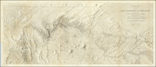
No Riverside or Imperial County
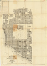
San Diego and Part of San Bernardino Counties, published by Rand McNally & Company in Chicago in 1892, provides a scarce and detailed view of these regions within Southern California. Featuring numerous small towns, railroads, rivers, mountains, Indian villages, railway stations, mines, and other details, it is notable as one of the few separate maps of this region to appear in a commercial atlas during this period.
The late 19th century was a time of significant growth and transformation in Southern California. With the development of railroads and the discovery of valuable minerals, regions like San Diego and San Bernardino saw an influx of settlers and economic activity. The absence of Riverside or Imperial County on the map reflects the geographical and administrative landscape of the time, before these counties were fully established.
The map's rich detailing makes it a valuable resource for understanding the historical geography of the area. The depiction of Indian villages, railway stations, and mines offers insights into the diverse communities, transportation networks, and economic activities that characterized the region. The inclusion of natural features like rivers and mountains adds to the depth of information, portraying the varied landscapes that shaped human settlement and development.
Rand McNally & Co. is a large American map and navigation company best known for its annual atlases. The company got its start in 1856, when William Rand opened a print shop in Chicago. He was joined in 1858 by a new employee, Andrew McNally. Together, the men established their namesake company in 1868. Originally, the company was intended to print the tickets and timetables for the trains running to and through Chicago; their first railway guide was published in 1869.
By 1870, they had shifted from just printing to publishing directories, travel guides, and newspapers. Their first map appeared in 1872 in a railway guide. The map was produced using a new wax engraving method, a cheaper process that gave the company an edge.
By 1880 Rand McNally had entered the education market with globes, wall maps, and geography texts for students. In 1923, Rand McNally published the first Goode’s World Atlas, named after its editor, Dr. J. Paul Goode. For generations afterward, this would be the standard classroom atlas.
In 1899, William Rand left the company, but McNally and his family remained, controlling the company for over a century. In 1904, they published their first road map intended for automobiles and by 1907 were publishing Photo-Auto Guides, which combined photography and mapping to help drivers. In 1924, they produced the Auto Chum, a precursor to their famous road atlases. Rand McNally would remain the leader in road maps and atlases throughout the twentieth century.
In 1937, Rand McNally opened its first store in New York City. Ever on the frontier of technology, Rand McNally pioneered the scribing process for printing tickets in 1958 and printed their first full-color road atlas in 1960. Arthur Robinson developed his now-famous projection of Rand McNally in 1969. By the 1980s, the company was exploring digital reproduction and digital databases of maps for truckers. In the 1990s, they lead the charge to develop trip-planning software and websites. Today, most of its products are available online or in a digital format, including maps for tablets and phones.
![[ Exceptional original hand-color with highlights in gold ] Typus Aspectuum Oppositionum Et Coniunctionum Etz In Planetis](https://storage.googleapis.com/raremaps/img/small/81866.jpg)