


|
||

|

|
|

|
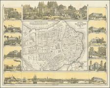
An Important Early Map / Graphic Illustrating Cuba's History
Rare second state of Bernardo May's map of Cuba, one of the richest images of Cuba printed in the 19th century.
May's map provides a depiction of the history of modern Cuba. The lithographed and tinted map, with 16 small views in the margin tells the modern story of the island, showing important events, local economic features, and culture.
The images are based on the very important early views produced in Cuba by its first lithographer, F. Mialhe. So influential was his work throughout the Americas and Europe that Emilio Cueto asserts: "The image which the enlightened public of the nineteenth century had of Cuba was the one conveyed by Mialhe"--p. 6. Among the subjects of the illustrations are the cultivation of tobacco, a formal dance, a cock fight, a hurricane at its height, various regional domiciles, etc. The plan of Havana includes a view of the city from the harbor.
The genesis of these works involves a fascinating case of graphic piracy. May, a Havana merchant, sent without authorization a number of Mialhe's original views to Germany to be re-lithographed. These were then sent back to Cuba, where May sold them at a price that undercut Mialhe's. Although Mialhe brought suit, the case was settled to May's advantage because Mialhe failed to follow the exact procedures of the then newly enacted copyright laws.
May's maps are, however, more 'original' than May's other piracies of Mialhe, since Mialhe never prepared a map.
Rarity
Bernardo May's Modern Cuba map and his Modern Plan of Havana appear occasionally on the market.
![[Florida Keys, Cuba, Bahamas, Cayman Islands] The Island of Cuba with part of the Bahama Banks & the Martyrs . . .](https://storage.googleapis.com/raremaps/img/small/85166.jpg)
![[Turks & Caicos, Bahamas, Hispaniola and Cuba]. Carte Reduite Des Debouquements, De St. Domingue, Levee, Dressee et Publiee par Ordre du Roi . . . 1787](https://storage.googleapis.com/raremaps/img/small/83475.jpg)
![[Cuba] Croquis de la Provincia De Puerto Principe Formado por el E. M. de la Capitania General de la Isla de Cuba ampliado y stampado en colors por el Deposito de la Guerra 1896](https://storage.googleapis.com/raremaps/img/small/33368.jpg)
