


|
||

|

|
|

|
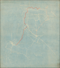
Shows the Santa Barbara Line of the Southern Pacific Railroad
The map covers the coast from just west of Isla Vista to Point Conception, centeed on the Los Alamos Valley and extending north to Santa Maria and the northern parts of the Santa Barbara National Forest.
The United States Geological Survey (USGS) Topographical map titled "Lompoc Quadrangle" provides a valuable snapshot into the evolution of the country’s understanding of its terrain. Issued initially in 1905 and subsequently updated in 1927, this map represents more than just contours and elevations; it tells a story of the hard work, dedication, and precision that early geographers and topographers brought to their craft.
The triangulation of the map, a method used to determine exact locations by measuring angles from fixed points, was executed by C.F. Urquhart. Triangulation was crucial for accurate mapping, ensuring that all points on the map were correctly situated relative to one another. S.N., responsible for the topography, had the task of detailing the surface features of the landscape. The survey done in 1890-91 would have involved a team moving through the landscape, taking measurements, and noting features, a formidable task in an era without modern conveniences or technology.
![(Bird's-Eye View of California) San Francisco Invites You [cover title]](https://storage.googleapis.com/raremaps/img/small/92552.jpg)
![[ Death Valley - Furnace Creek Ranch ]](https://storage.googleapis.com/raremaps/img/small/98985.jpg)