|
||

|

|
|

|
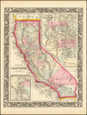
Scarce pocket map of California and Nevada, colored by counties. This map was published by G.W. & C. B. Colton in New York in 1879.
The map provides a finely detailed treatment of California and Nevada, at a time when California was growing and diversifying, and Nevada was becoming one of the most important mining states in the country.
The map shows the progress of the township surveys throughout the two states. There is excellent topographical detail, along with cities, railroad lines, wagon trails, mining details, and other sites.
The counties in Southern California are still relatively incomplete, with Imperial, Riverside, and Orange County not yet formed.
Rarity
This is only the second time in 25 years that we have offered the pocket map edition of this map.
G. W. & C. B. Colton was a prominent family firm of mapmakers who were leaders in the American map trade in the nineteenth century. The business was founded by Joseph Hutchins Colton (1800-1893) who bought copyrights to existing maps and oversaw their production. By the 1850s, their output had expanded to include original maps, guidebooks, atlases, and railroad maps. Joseph was succeeded by his sons, George Woolworth (1827-1901) and Charles B. Colton (1831-1916). The firm was renamed G. W. & C. B. Colton as a result. George is thought responsible for their best-known work, the General Atlas, originally published under that title in 1857. In 1898, the brothers merged their business and the firm became Colton, Ohman, & Co., which operated until 1901, when August R. Ohman took on the business alone and dropped the Colton name.
![[Alaska to San Diego and San Qunitin, British Columbia] A Chart Shewing Part of the Coast of N.W. America, with the Tracks of His Majesty's Sloop Discovery and Armed Tender Chatham . . . (First Modern Map of the West Coast of North America)](https://storage.googleapis.com/raremaps/img/small/102067.jpg)
![[California Road Atlas] Easy Fold Maps of California Highways](https://storage.googleapis.com/raremaps/img/small/73977.jpg)