|
||

|

|
|

|
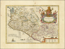
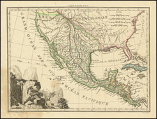
Philippe Vandermaelen, a Belgian cartographer, is well known for his revolutionary six-volume atlas that presented the world on a uniform scale for the first time. One of these exceptional maps, circa 1825, provides an intricately detailed regional representation of parts of Southern Mexico and Guatemala. It extends south to the Volcan de Sonsonale and Pta. De Acazutlo, both located in El Salvador, and reaches west to Oaxaca, northward to include the southern parts of Tabasco. The level of detail and emphasis on the mountainous topographical features of the region are particularly noteworthy.
The map depicts the region's mountainous terrain with extraordinary precision. Major mountain ranges, such as the Sierra Madre de Chiapas and the Cuchumatanes in Guatemala, are vividly displayed, underlining the significant role they play in influencing the region's climate, biodiversity, and human settlements. Individual volcanic peaks like the Volcan de Sonsonale are marked, a testament to the region's geological dynamism.
Complementing the topographical details are the clearly marked rivers that weave through the region. Notable rivers such as the Grijalva in Mexico, and the Motagua in Guatemala are depicted. These rivers, fundamental to the region's ecology and human livelihood, highlight the importance of waterways for transportation, agriculture, and the development of settlements.
Moreover, the roads and towns scattered across the region are meticulously rendered. This level of detail gives an indication of the human presence and the infrastructural development in these parts of Southern Mexico and Guatemala during the early 19th century.
Major regions including Oaxaca, Tabasco, Chiapas, Verapaz, and Guatemala are highlighted on the map. Each of these regions carries its own historical and cultural significance. For instance, Oaxaca, known for its indigenous cultures and archaeological sites, and Chiapas, with its rich biodiversity and Mayan heritage, are both distinctive regions of Mexico. In Guatemala, Verapaz stands out for its unique natural beauty and bird species, while the region named after the country itself hosts the vibrant capital city, Guatemala City.
The achievement of Vandermaelen's map extends beyond its detail and accuracy. It is part of his monumental six-volume atlas, which when combined as globe gores, forms an immense globe. This atlas marked a groundbreaking development in cartography – the first atlas mapping of the world on a uniform scale. This uniformity offered a new perspective of the world, enabling easier comparison of different regions' geographical features.
Philippe Marie Vandermaelen (1795-1869) was a Belgian cartographer and geographer known for his pioneering use of technology and his leadership in establishing the important Establissement geographique de Bruxelles. Born in Brussels, Philippe was obsessed with maps from a young age. He taught himself mathematics, astronomy, and mapmaking and plotted the battles of the Napoleonic wars avidly. He took over his father’s soapmaking business briefly in 1816, but then turned it over to his brother in favor of cartography.
From 1825 to 1827, he released his first atlas, the Atlas universal, which was well received. It was sold in forty installments of ten maps each, with 810 subscribers listed. The atlas contained 387 maps in six volumes at a uniform scale of 1:1.6 million. The maps were intended to be joined and together would create a globe 7.755 meters wide. It was the first atlas to show the entire world on a large uniform scale and was the first atlas produced using lithography. This project served as Vandermaelen’s gateway into intellectual life, gaining him membership in the Royal Academy of Sciences and Belles-Lettres of Brussels (1829).
In 1830, Vandermaelen inherited a laundry from his parents which he converted into the Establissement geographique de Bruxelles, or the Brussels Geographical Establishment. His brother, Jean-Francois, also established a botanical garden on the site. The Establishment had its own lithographic press, one of the first to use the technology for cartography and the first in Belgium. They produced textbooks, surveys, and especially maps of Brussels to be used for urban planning. The complex also housed schools, an ethnographic museum, and a library open to the public. Vandermaelen was passionate about geographic education and saw the Establishment as an open place where people could learn about the world.
In 1836, he was knighted for his services to geography and the intellectual community of Belgium. He died at age 73 in Molenbeek-Saint-Jean, near the Geographical Establishment that he founded. After Vandermaelen’s death, the Geographical Establishment declined, closing its doors in 1880. The extraordinary collection they had amassed passed to several institutions, most importantly the Royal Library of Belgium.