|
||

|

|
|

|
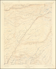
Nice example of Conrad Malte-Brun's marvelous map of Mexico and the Western Uninted States.
Conrad Malte Brun, while producing a relatively small set of maps in his Atlas Precis, was well respected and well placed in the food-chain of geographical knowledge. He utilzed his contacts and status in Paris to obtain geographical information soon after new discoveries were made and regularly updated his maps to reflect these discoveries.
The present map is an excellent example, which over the course of several states reveals the explorations and expanding knowledge of the Transmississippi West.
This second state of Malte-Brun's map is the first to incorporate the information from Humboldt, Pike and Lewis & Clark. It is the earliest known map to show a continuous waterway from the Great Salt Lake to San Francisco Bay, the mythical Rio Buenaventura.
In this second edition, there are significant changes. The name Louisiana is removed and the Missouri river shows the Big Bend, reflecting the information from Lewis & Clark's expedition. The mountain ranges in the area of Utah and Nevada have been removed, as have the apocryphal rivers, perhaps based in part on information derived from Arrowsmith. A definitive "Adams Onis" northern border between the US and Upper California is shown, whereas there has been no boundary in the earlier edition. Lake Teguayo and Timpanagos are much more boldly shown and are depicted in their large and more familiar shape.
A link to the earlier edition can be found here : /gallery/detail/26214
Malte-Brun's maps are often overlooked, despite his tireless efforts to provide up to date cartographic information.

![[ Chinese Voyages To America, etc. ] Memoires De Litterature, Tires Des Registres De L'Academie Royale Des Inscriptions et Belles-Lettres Depuis l' annee M. DCC. XVIII. julques & compris l'annee M. DCC. XXV Tome Quarante-Neuvieme](https://storage.googleapis.com/raremaps/img/small/101296.jpg)