|
||

|

|
|

|
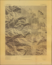
Palm Springs Quadrangle California 7.5 Minute Series (Orthophotoquad), produced by the U.S. Geological Survey and published in cooperation with the Soil Conservation Service in 1977, is an authoritative aerial photograph of Palm Springs, California.
The late 1970s marked a period of robust development and demographic growth for Palm Springs, which, once a desert retreat, was burgeoning as a sought-after destination for leisure, wellness, and cultural activities. This was also a time when advances in cartographic technologies, such as aerial photography, allowed for more detailed and accurate representations of landscapes and terrains. The Palm Springs Quadrangle stands as a testament to this era, with its orthophotograph sourced from aerial shots taken in October 1975.
The mapping technique adopted here, the 1:80,000-scale aerial photograph, paired with the California coordinate system and the Universal Transverse Mercator grid, ensures a precise representation of Palm Springs. Beyond mere geographical features, the inclusion of elements such as principal numbered highways—Interstate Routes, U.S. Routes, and State Routes—serves as an indication of the infrastructural developments of the time and Palm Springs' increasing connectivity with its surroundings.
Despite its precise nature, the map's photoimagery underwent scanning techniques which might lead to double or mismatched images. Users are thus advised to interpret the mean of image positions for accurate map points. This aspect, while a potential limitation, also underscores the transition period in mapping technologies of the 1970s, bridging traditional cartography with the dawn of the digital age.
![The Monterey Peninsula California Pinto Guide Map to Fine Accommodations Restaurants Theatres Services Shops [double sided map]](https://storage.googleapis.com/raremaps/img/small/102769.jpg)

![[Early Panoramic Photo of the Balboa Pavilion, Newport Beach]](https://storage.googleapis.com/raremaps/img/small/74933.jpg)