|
||

|

|
|

|
Stock# 96533
Description
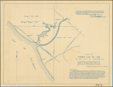
Detailed map of a the proposed route (in Yellow) identifying the road leading the the future Mount Hope Cemetery, drawn by San Diego City Engineer Edwin Capps.
The map shows the area from today's 32nd Street to Pascoe Street (36th) on the edge of the cemetery, which had been founded in 1869.
Condition Description
Pen & Ink on drafting linen.
![[ Southern California Tourism ] Hunting and Fishing in Southern California on the Santa Fe](https://storage.googleapis.com/raremaps/img/small/101613.jpg)