|
||

|

|
|

|
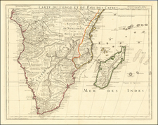
Colton's Africa (Southern Sheet), published by G.W. and C.B. Colton & Co. in New York in 1855, delineates the southern regions of the African continent, including territories such as Cape Colony, Free States, Natal, Orange River, Trans Vaal Republic, Mozambique, Zanguebar, Makololo, and Ovaherero Damara. Strikingly, the map also designates a large area marked as "UNEXPLORED REGION" in what is now the Democratic Republic of the Congo.
During the mid-19th century, the mapping of Africa was in a state of transformation as European explorers ventured into previously unknown regions. This particular map reflects the limited Western knowledge of the African interior at the time, combining well-charted coastal areas with vast inland territories labeled as unexplored.
The delineation of territories such as the Cape Colony, Free States, and others illustrates the political landscape influenced by European colonization, with borders reflecting the claims and divisions imposed by various colonial powers. The inclusion of indigenous territories like Makololo and Ovaherero Damara hints at the complex interactions between European and African societies during this period.
Colton's Africa (Southern Sheet) is an object of a time when the geography of Africa was still a subject of exploration and speculation. It stands as a testament to the changing perceptions of the continent, embodying both the scientific endeavor to chart the unknown and the political dynamics of an age marked by colonization and expansion. The map offers insights into how the African landscape was perceived, understood, and represented in the mid-19th century, reflecting a complex interplay of exploration, colonialism, and cartographic artistry.
G. W. & C. B. Colton was a prominent family firm of mapmakers who were leaders in the American map trade in the nineteenth century. The business was founded by Joseph Hutchins Colton (1800-1893) who bought copyrights to existing maps and oversaw their production. By the 1850s, their output had expanded to include original maps, guidebooks, atlases, and railroad maps. Joseph was succeeded by his sons, George Woolworth (1827-1901) and Charles B. Colton (1831-1916). The firm was renamed G. W. & C. B. Colton as a result. George is thought responsible for their best-known work, the General Atlas, originally published under that title in 1857. In 1898, the brothers merged their business and the firm became Colton, Ohman, & Co., which operated until 1901, when August R. Ohman took on the business alone and dropped the Colton name.
![(South Africa) Coutumes Moeurs & Habillemens des Peuples Qui Habitent aux Environs du Cap de Bonne Esperance avec une Description des Animaux et Reptiles qui set truvent dans ce Pais [Customs, Manners, and Attire of the Peoples Who Inhabit the Vicinity of the Cape of Good Hope, with a Description of the Animals and Reptiles Found in this Country.]](https://storage.googleapis.com/raremaps/img/small/89738.jpg)
![[South Africa / Algoa Bay, Mossel Bay / Vleesbai ] The Bay of Algoa on the South Coast of Africa . . . | Plan of Mossel Bay on the South Coast of Africa . . . | Plan of Flesh Bay or Bay of St. Bras on The South Coast of Africa](https://storage.googleapis.com/raremaps/img/small/85695.jpg)
![[Luanda, Angola] Eroberung der Statt Loando de Sanct Paolo in Angola in Africa. Gelegen](https://storage.googleapis.com/raremaps/img/small/85194.jpg)