|
||

|

|
|

|
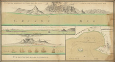
A remarkable representation of early 18th-century cartography, Henri Chatelain's "Coutumes, Moeurs & Habillemens des Peuples qui Habitent aux Environs du Cap de Bonne Esperance Avec Une Description Des Animaux et Reptiles Qui Se Trouvent Dans Ce Païs" encapsulates the essence of life and biodiversity in the vicinity of the Cape of Good Hope. Authored in 1719 in Amsterdam, the chart captures an array of human customs, indigenous attire, and the rich variety of local fauna, a testament to Chatelain's scholarly attention to detail and breadth of understanding.
The chart is part of Chatelain’s monumental 7-volume "Atlas Historique," an acclaimed work of the early 18th century. It vividly portrays the customs and habits of the local people, capturing a unique snapshot of life around the Cape of Good Hope. In addition to the human element, the chart dives into the natural world, with a meticulous enumeration of animals and reptiles found in the region. The reader can discern the details of the native wildlife, including descriptions of the rhinoceros, marine cows, and various lizards, illustrating the broad biodiversity of the area.
In a historical context, Chatelain's chart was groundbreaking for its time. It showcased the diversity of the region in a period when exploration and natural science were in their infancy. The vivid descriptions of local customs and wildlife became a valuable resource for further European exploration and colonization in the region. Moreover, the chart is a testament to the Enlightenment’s ethos of encyclopedic knowledge, which sought to catalog and understand the diversity of the world.
While it remains firmly a product of its time, the chart also exhibits an early acknowledgement of cultural and biological diversity. Chatelain's work, despite the biases and limitations of 18th-century knowledge, provides an insight into an era of exploration and discovery. Its rich details, striking engraving, and broad coverage of the region around the Cape of Good Hope make it a noteworthy piece within the broader tapestry of historical cartography.
Henri Abraham Chatelain (1684-1743) was a Huguenot pastor of Parisian origins. Chatelain proved a successful businessman, creating lucrative networks in London, The Hague, and then Amsterdam. He is most well known for the Atlas Historique, published in seven volumes between 1705 and 1720. This encyclopedic work was devoted to the history and genealogy of the continents, discussing such topics as geography, cosmography, topography, heraldry, and ethnography. Published thanks to a partnership between Henri, his father, Zacharie, and his younger brother, also Zacharie, the text was contributed to by Nicolas Gueudeville, a French geographer. The maps were by Henri, largely after the work of Guillaume Delisle, and they offered the general reader a window into the emerging world of the eighteenth century.
![[Orange Free State, Transvaal, Natal and Part of the Cape Colony] Africa do Sul Folha 1 | Estado Livre d'Orange, Natal, e regiones que limitam com o Transvaal e Colonia do Cabo](https://storage.googleapis.com/raremaps/img/small/90963.jpg)
![Colton's Africa [Southern Sheet]](https://storage.googleapis.com/raremaps/img/small/98349.jpg)
![[South Africa / Namibia / Angola] Coste Occidentale D'Afrique Depuis le XIe. Degre De Latitude Meridional, Jusqua'au Cap de Bonne Esperance Tiree de la Carte de l'Ocean Meridional . . . 1739](https://storage.googleapis.com/raremaps/img/small/77033.jpg)