|
||

|

|
|

|
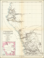
A Meticulous Mapping of Southern Nigeria Under British Rule
An extraordinarily detailed map of the the Central and Eastern provinces of Southern Nigeria, providing a remarkable level of details.
The map of Southern Nigeria was created under the guidance of Captain W.H. Beverley, the Intelligence Officer for Southern Nigeria. This map was based on surveys conducted by several officers and individuals: Capt. Woodroffe, Capt. Moir, Lieut. King, Lieut. Hearson, E.P. Cotton, as well as officers from the Southern Nigeria Marine. Additionally, sketches by officers of the Southern Nigeria Regiment and Political Officers overseeing various districts contributed to its details. The final map was drawn and engraved at Stanford's Geographical Establishment.
Post the Napoleonic Wars, the 19th century saw an expansion of British trade into Nigeria's interior. In 1885, Britain's influence in West Africa was internationally acknowledged. A pivotal development was the chartering of the Royal Niger Company in 1886 under Sir George Taubman Goldie. However, by the close of the century, on December 31, 1899, this charter was annulled, leading to the British government's takeover of the territory previously under the Company.
With the dawn of the 20th century, two significant protectorates were established in Nigeria: the Southern and Northern Nigeria Protectorates. These were amalgamated in 1914, giving rise to the Colony and Protectorate of Nigeria. This period witnessed a distinction in development between the north and the south. The southern region saw quicker advancements in western education and a modern economy, a disparity that echoed in Nigerian politics thereafter.
The reference key shows symbols for the following:
- Provincial Headquarters also Headquarters of Calabar and Warri Districts.
- District Headquarters: Courts and Resthouses are established at these stations.
- Native Court:
- Resthouse.
- Post Office or Postal Agency.
- Public Telegraph office.
- Principal Protestant and Roman Catholic Mission Stations.
- 1st Class Roads: Permanent main roads constructed by the Government Roads Department and Political Officers; they are all well graded and bridged, average 15 feet in width and are suitable for light traffic. Where metalled, heavy traffic can run over them
- 2nd Class Roads: Constructed under the supervision of Military and Political Officers. In some cases, traces were marked out by Road Engineers. they are bridged, average 15 feet in width, are to a certain extent graded and suitable for light traffic.
- 3rd Class Roads: Native paths that have been straightened and cleaned. they average 8 feet in width and in nearly all cases can be cycled over
- Native Paths
- Telegraph
- Telegraph along a road.
- Administrative Districts (red letters)'
- Principal Native Tribes.(capital black letters)
- Small native Tribes (small black letters)
- Note: The 't' when followed by another word is pronounced as 'r', e.g., Ikot Ekpene is pronounced Ikor Ekpene.
- Market places in the districts inhabited by the Ibo tribe are marked as: Afor. Eke. Newor. and Orio which signifies the day on which the market is held)
- A Factory: The West African term for a Trading Company's Station.
Edward Stanford (1827-1904) was a prominent British mapmaker and publisher. A native of Holborn in the heart of London, Edward was apprenticed to a printer and stationer at the age of 14. After his first master died, he worked with several others, including Trelawny W. Saunders of Charing Cross. Saunders oversaw young Edward’s early career, ensuring that he became a Fellow of the Royal Geographical Society. Associations with the Society eventually brought Sanders much business and gave him a reputation as a publisher of explorers. As testament to this reputation, the Stanford Range in British Columbia was named for him by John Palliser.
Stanford briefly partnered with Saunders in 1852 before striking out on his own in 1853. He was an agent for the Ordnance Survey, the Admiralty, the Geological Survey, the Trigonometrical Survey of India, and the India Office. He also controlled the maps of the Society for the Diffusion of Useful Knowledge, another lucrative source of income. In 1857, Stanford founded his namesake Geographical Establishment, with Saunders and A. K. Johnston as engravers. Thereafter, Stanford was known for his “library maps”, particularly those of Africa and Asia.
Addresses and Years of Operation:
- 6 Charing Cross, London (1848): Edward Stanford's initial place of employment at Trelawney Saunders' shop.
- 7 and 8 Charing Cross, London (1853): Stanford expanded his shop to these addresses.
- 55 Charing Cross, London (1873): The shop moved to this larger location.
- 12-14 Long Acre, London (1873): Site of the new print works and current flagship store.
- 7 Mercer Walk, London (2019): Stanfords moved to this address, continuing its legacy.
Stanford's work with Chief Cartographer John Bolton, including the 1858 Library Map of Europe, positioned the company as a leader in quality cartography during a time of exploration and colonialism. Their 1862 Library Map of London earned acclaim from the Royal Geographical Society. With the business thriving, Stanford purchased Staunton & Son in 1877 and, upon retiring in 1885, handed over the reins to his son, Edward Stanford II.
As sole agents for Ordnance Survey Maps, the company's influence and reputation grew, culminating in the Stanford’s London Atlas Of Universal Geography, which was presented to Queen Victoria in 1887. The transition into the 20th century saw further integration of retail, print, and cartographic operations at Long Acre.
During World War I, Stanford's became an essential publisher for the War Office. Edward Fraser Stanford took over in 1917, steering the company through the interwar period and innovations, such as the world’s smallest maps in 1922 and the Daily Mail Motor Road Map in 1926.
Withstanding a bombing in WWII, the company continued under the stewardship of John Keith Stanford and was sold to George Philip & Son in 1947. As it adapted to the digital age, Stanfords received the Ordnance Survey Premier Partner status in 2007 and ventured into online mapping and data services.
Stanfords, now an icon for travellers and explorers, has maintained its cultural relevance and retail success well into the 21st century, underpinned by a legacy of entrepreneurial spirit and commitment to cartographic excellence.
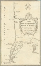
![Fessae, et Marocchi Regna Africae Celeberr. describebat Abrah. Ortelius. 1595 [with large inset of West Africa]](https://storage.googleapis.com/raremaps/img/small/95634.jpg)