|
||

|

|
|

|
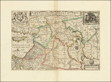
The seventeenth-century map of the Holy Land, focusing on the Israelites' Exodus from Egypt, is a fascinating blend of geography and history, deeply imbued with religious significance. Rich with Latin inscriptions, this cartographical work illustrates a significant era of the Old Testament, capturing the Israelites' forty-two-year-long journey from Egypt to the Promised Land. Along the route, it meticulously highlights major rivers, mountains, and towns, with a distinct depiction of the commencement of the journey at the lower left and the final crossing of the Jordan River to the north of the Dead Sea.
The journey, as shown in the map, commences at "Mansio dicta Ramesses." The Latin phrase translates as "dwelling named Ramesses." This is the ancient city of Ramesses, from where the Israelites supposedly began their Exodus, as mentioned in the Bible's Book of Exodus (Exodus 12:37).
From Ramesses, the map depicts the path leading "Via quae ducit ad Philisthaeo et inde in Chaanan." In English, this translates to "the road that leads to Philistia and then to Canaan." Philistia, traditionally the land of the Philistines, was located along the eastern Mediterranean coast. From Philistia, the map illustrates the progression towards Canaan, the ultimate destination and the Promised Land.
Along the journey, the map notes the "Via qua ducit ad montem Sinaie," translating as "the road that leads to Mount Sinai." Mount Sinai is traditionally believed to be the mountain at which the Ten Commandments were given to Moses by God. This location is an extremely significant point in the Israelites' journey, marking a divine intervention and offering spiritual guidance for the wandering nation.
The map shows the exodus trail approaching the "Via quae ducit ad Mare," which translates to "the road that leads to the Sea." The sea would be the Red Sea, where earlier in the fourth year of the journey, Moses, by God's command, parted the sea to pave a path for the Israelites and escape the pursuing Egyptian army.
The Latin phrase "Funiculus terminans ab Austro Terram Channan," when translated into English, is indeed "a border ending from the south of the land of Canaan," however, its contextual interpretation within the scope of this map and the Exodus narrative merits further clarification. Rather than simply indicating the northernmost point of the initial half of the Exodus, it more aptly represents a southerly boundary marker of the land of Canaan.
In the chronology of the Exodus, around the fifteenth year, the Israelites arrived at a location referred to as Rethma. Not much is known historically about this place, but it is mentioned in the Bible, specifically in the book of Numbers (33:18-19), as one of the many stations or encampments during the Israelites' wanderings in the wilderness. Upon reaching Rethma, the narrative path of the Exodus, as depicted in the map, takes an unexpected turn. Instead of heading directly north towards Canaan, it veers south for the next fifteen years. This diversion represents a period of the Exodus often referred to as the "wanderings" — a time when the Israelites were said to have moved in a seemingly aimless manner throughout the Sinai desert.
This southerly detour, rich in trials and tribulations, is a significant part of the Exodus narrative, reflecting the Israelites' struggles with faith and obedience. The lessons learned during these wanderings would serve to shape the Israelites as a nation under the covenant of their God.
After these fifteen years of southern wanderings, the journey of the Israelites resumed a more northerly direction. The map portrays this shift as the path moving to the east of the Dead Sea. The traversal of this region would lead the Israelites through what is now modern-day Saudi Arabia and Jordan.
The final stages of the Exodus, as indicated on the map, lead to "Campesina Moab" and then across the Jordan River. Campesina Moab translates to the "Plains of Moab," a fertile plain in Jordan, where the Israelites camped before they crossed the Jordan River. This was a crucial staging area where Moses delivered his final sermons, recorded in the book of Deuteronomy, and where he passed away just before the Israelites entered the Promised Land.
The crossing of the Jordan River was a culminating moment in the Exodus narrative. It marked the end of a long, arduous journey and the beginning of a new chapter as the Israelites finally reached the Promised Land, their land of Canaan. Thus, the Latin inscription "Funiculus terminans ab Austro Terram Channan" indeed marks a border, but more importantly, it signifies the threshold of a dream realized and a promise fulfilled.
Lastly, the map indicates the area "Terra Philistihnorum" to the north. This term translates to "the land of the Philistines," an ancient people who lived on the south coast of Canaan.
The pictorial and textual details in the map, combined with translations and biblical references, depict a powerful narrative of faith, resilience, and divine providence. As a cartographical piece, it provides geographical insight into a spiritual journey, while as a historical document, it encapsulates the cultural and religious sentiments of the seventeenth-century era when it was created.
![[Holy Land] Terra Chanaan Ad Abrahami Temora Per Populos. XI Item per Toparchias Idumaeae totidem, et Stationes XLV ad MosisTempora, seu Tabula digesta ad Libros Genes, Exodi, Levit, Numer, et Deuteron](https://storage.googleapis.com/raremaps/img/small/85297.jpg)
![[ Catholic Missions in the Ottoman Empire ]. Carte Ecclesiastique de L'Empire Ottoman d'apres les Missiones Catholicae](https://storage.googleapis.com/raremaps/img/small/88303.jpg)