|
||

|

|
|

|
Stock# 75406
Description
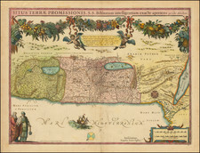
Attractive early map of the Holy Land and adjoining regions, with many regions named. Many early towns and biblical place names are depicted including the cities of Babel and Ptolemais, as well as more local attractions such as Sarah's Cave or the land of the Moabites.
This map is based on the earlier Visscher map of the region, from 1671, which, along with five other maps were translated into English by Joseph Moxon. In 1691, the map appeared in Moxon's Sacred Geographie or Scriptural Mapps. This example first appeared in The Holy Bible, from 1715
This map is uncommon on the market. It is the first time we have offered it for sale.
Condition Description
Original hand-color. Light centerfold toning.
![[ Catholic Missions in the Ottoman Empire ]. Carte Ecclesiastique de L'Empire Ottoman d'apres les Missiones Catholicae](https://storage.googleapis.com/raremaps/img/small/88303.jpg)
![Turcia Turci Cive Imperii seu Solij mannorum regni pleraque pars nunc recens Summa fide ac indusrai elucubrata | Natoliam Moderni dicunt tam partem quam Asiam minrem appelauere veteres. [shows Cyprus]](https://storage.googleapis.com/raremaps/img/small/86757.jpg)
![[ Biblical Names for Palestine ]. Carte de La Palestine Ancienne et Moderne avec le Sud du Liban et de l'Anti-Liban et les régions situées à l'est du Jourdain et de la Mer Morte, pour servir à l'étude de la Bible par A. Legendre [Map of Ancient and Modern Palestine with Southern Lebanon and Anti-Lebanon and the regions east of the Jordan and the Dead Sea, for use in the study of the Bible by A. Legendre]](https://storage.googleapis.com/raremaps/img/small/85737.jpg)