


|
||

|

|
|

|
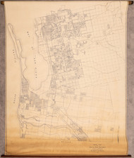
19th-Century Elsinore Township Map and the California Southern Railroad
This rare circa 1885 manuscript map of Elsinore, when it was still part of San Diego County, was drafted by Pennington W. Minthorn, a pioneer surveyor in Southern California, and an uncle of the future United States President, Herbert Hoover. Carefully rendered on drafting linen, the map delineates the then-town site that would eventually develop into Lake Elsinore, along with the lake itself, the California Southern Railroad, and Elsinore Station. The map was made as an exhibit in a legal case, likely involving the California Southern right of way.
During the late 19th century, Southern California was undergoing dramatic changes as a result of burgeoning population growth and infrastructural development. Minthorn's map offers a snapshot of this transitional phase, showing Elsinore, now known as Lake Elsinore, when it was still part of San Diego County.
Although the formation of Riverside County [in 1893] subtracted several of the Temecula Valley settlements from San Diego County, the California Southern line, San Diego's chief railway venture, was responsible for starting most of them. Therefore, they may fittingly be considered in connection with other San Diego enterprises, particularly as they were still included in San Diego County during the boom... Elsinore was located on the northeastern shore of the lake of that name, and resulted from the activity of a syndicate, formed in 1884, which bought some of the Laguna Ranch lands. The region was acclaimed for its hot springs and its consequent suitability as a health resort - Dumke, The Boom of the Eighties in Southern California, page 152.
A selection of sites shown on the map here follows:
- Lake Elsinore
- Town site on northeastern shore of the lake
- Property of G. S. Irish - listed as George S. Irish, horticulturist, in Riverside Directory of 1893-94.
- San Jacinto River
- County Bridge
- Streets: Machado, Rice, Lincoln, Cruwell, Spring, Minthorn, Chino, Corydon, Santa Rosa, and Riverside; and Collier Ave. and Grand Ave.
Lake Elsinore
Situated in Southern California, Lake Elsinore is the largest natural freshwater lake in the region. The area's earliest known inhabitants were the Luiseño people, an indigenous group that utilized the region's resources for sustenance. In the late 18th century, Spanish explorers and missionaries arrived and named the water body Laguna Grande, spurring significant changes in the area's socio-cultural dynamics. Substantial development began in the late 19th century during the Southern California land boom, when Franklin Heald planned a town near the lake in 1883, initially naming it Elsinore. The area's integration into the transportation network, specifically through the establishment of the California Southern Railroad in the 1880s, initiated further growth and led to the area's eventual recognition as Lake Elsinore.
Pennington W. Minthorn, the map's creator, holds a significant place in Southern California's history as a pioneer surveyor. Born in Canada around 1857, Minthorn moved to the United States as a young boy. His work as a surveyor contributed to the development and growth of Southern California during a period of considerable transformation. The fact that he was an uncle to Herbert Hoover, the 31st President of the United States, provides an interesting familial connection. Minthorn died in Northridge, California in 1940 at the age of 83.
This manuscript survey is a historically significant object that offers valuable insights into Southern California's development during the late 19th century. Created by a pioneer surveyor who played a critical role in shaping the region, the map is an important contribution to the historical cartography of the area. Furthermore, its depiction of Lake Elsinore and its surroundings prior to the establishment of Riverside County adds an additional layer of historical significance, making it a valuable resource for those studying the history of California's geographical development.
Rarity
19th-century manuscript maps of Lake Elsinore are very rare on the market. The present map, likely done soon after the townsite was laid out, circa 1885, stands as one of the earliest extant maps of Elsinore.
![[ Los Angeles / Harris Newmark ] Newmark Block Junction of Main and Spring Sts., Los Angeles, Cal.](https://storage.googleapis.com/raremaps/img/small/97889.jpg)
![San Bernardino County [and:] Southwest Portion of San Bernardino County](https://storage.googleapis.com/raremaps/img/small/96727.jpg)