|
||

|

|
|

|
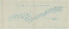
Early La Jolla Map Showing Subdivision of the Beach Barber Tract
Exceptionally rare and early La Jolla subdivision map, representing the first plotting of a section of blocks adjacent to Windansea Beach. This fascinating map documents the early layout of what was then known as "South La Jolla," a stretch of land between Westbourne Street, Bonair Street, La Jolla Boulevard, and the Pacific Ocean located in the northern City of San Diego.
To the left of the map is the yet-to-be-named Windansea Beach, with a marked Pavilion (now the corner park overlooking the Windansea Shack) and a since disappeared Bath House between Bonair and Nautilus Streets. In the east is the north-south La Jolla Railroad, with a station on Westbourne Street that has now been replaced by a convenience store and classic La Jolla bar.
The survey was originally made in 1902, with this cyanotype representing an updated version to 1915. Furthermore, several changes have been made by hand, in red ink. For instance, Bonair, Nautilus, and Westbourne Avenues have been renamed as streets, and Westbourne has been narrowed by 20 feet, possibly in order to add sidewalks.
Pueblo Lot 1260
The Pueblo system in San Diego was initiated by King Charles IV in order to incentivize colonization of this far-flung outpost of the Spanish Empire. This system allowed for large land grants for settlers and subdivided the area around San Diego. However, much of the land remained unsettled and was transferred to the City of San Diego in 1848 to be held in trust as public land for the city's citizens. At the time, approximately 47,000 acres of Pueblo land remained between Chula Vista and Carmel Valley.
Over the next hundred and fifty years, lasting well into the second half of the 20th century, Pueblo Lands would be sold to developers and turned into developments. Pueblo Lot 1260, which stretches from Marine Street to Bonaire, would be sold in the late 19th century and subdivided by 1902.
"Neptunia" or the Beach-Barber Tract
The Beach-Barber Tract would be first known as "Neptunia" in 1899 following a naming contest in the San Diego Union Tribune. This stretch of land, sandwiched between La Jolla Boulevard and the Pacific Ocean, was centered on South La Jolla (shown in the map) and included the developments of "La Jolla Strand" to the south, and "La Jolla Beach" to the north.
Development would be limited between 1902 and 1921 in the South La Jolla area shown on the map, which leads to the rarity of early maps of this area. In 1921, the New York magnate Phillip Barber would create the first "housing development" in La Jolla, after he bought lands and built them with small, individually designed houses. Some of these cottages persist to this day and can be seen. However, Barber's main focus was to the north of the area shown on this map, so many lots in South La Jolla still remained undeveloped even into the second half of the 20th century.
Rarity
OCLC does not list any examples of this map. No reference to the duplicate of this map (Map 887) was available through the City of San Diego, though they may possess an archived example. We were unable to find any examples of this map on the market.
![[Escondido Area]](https://storage.googleapis.com/raremaps/img/small/71890.jpg)
![[ San Diego County / Julian Mining District ] Sixth Annual Report of the State Mineralogist. Part I for the year ending June 1st 1886.](https://storage.googleapis.com/raremaps/img/small/101709.jpg)