|
||

|

|
|

|
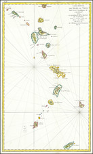
Isles Caribes is a decorative map from 1683 by Alain Manesson Mallet, illustrating the Antilles in exquisite detail, ranging from Puerto Rico in the northwest to Trinidad and Tobago in the southeast. The map features a collection of significant islands, such as Aruba, Bonaire, Curaçao, Tortuga, Grenada, Martinique, Dominica, Barbuda, Barbados, St. Barts, St. Kitts, St. Martin, and Guadeloupe. An additional layer of historical context is added through the depiction of several major sea battles.
In the 17th century, the Antilles served as a backdrop to colonial expansion, conflict, and trade among European powers, especially between the Spanish, English, and French empires. This map offers a snapshot of this tumultuous period, when the struggle for control over the rich resources and strategic advantages of the Caribbean was at its height. The depiction of several sea battles on the map illustrates the ongoing conflicts of the era, transforming the map into a canvas of colonial warfare and ambition.
Alain Manesson Mallet, an esteemed French cartographer and engineer, created this map for his notable work, Description de l' Univers. First published in Paris in 1683, this seminal five-volume publication covered a diverse range of topics, from geography and cosmography to history and architecture. The Isles Caribes is a part of this extensive work, reflecting Mallet's meticulous detailing and broad understanding of the world, particularly during the age of exploration and colonialism.
Alain Mannesson Mallet (1630-1706) was a French mapmaker and engineer who served in the armies of Louis XIV. After rising through the ranks, Mallet was appointed as Inspector of Fortifications, a job which also required mathematical skills and which made him a competent military engineer. Eventually, he joined the court of Louis XIV at Versailles, where he taught math and focused on writing.
Mallet is best known for his Description de L’Univers, first published in 1683, in five volumes. A wide-ranging geographical work, the Description included textual descriptions of the countries of the world, as well as maps of the celestial sky and the ancient and modern worlds. The Description continued to be published until the early eighteenth century. He also published a work in three volumes on warfare (1684) and a primer on geometry (1702).


![[ Charleston, Boston, New York, St. Augustine, Bahamas, etc ] Particular Draughts of some of the Principal Towns and Harbours belonging to the English French and Spanish in America and the West Indies.](https://storage.googleapis.com/raremaps/img/small/102804.jpg)