|
||

|

|
|

|
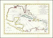
Fine example of this rare separately issued map of the Theater of War during the War of Jenkins Ear, published in London circa 1702, by Robert Morden & Herman Moll.
Produced during the War of Spanish Succession, (1701-1714) (for which the American part of the conflict was referred to as the War of Jenkin's Ear), the map provides a fine overview of the theater. Cartographically, the map is a curious amalgam of cartographic information along the Gulf Coast. The source of the Mississippi appears near Corpus Christie, a vestige of La Salle and Franquelin's work in the early 1680s and thereafter followed by Rossi, Coronell, Roillard, De Fer and Morden in the 1690s.
The map was the subject of some dispute with French mapmaker Pieter Mortier, who Morden accused of plagiary. This second edition of the map included the following note at the top right:
Whereas Peter Mortier Bookseller of Amsterdam hath lately published an inperfect Coppy of a Map entitled the Seat of War in the West Indies &c. to which he hath affixed his own name, and therin vainly assumed the title of Geographer tho he understands nothing of a Map, and yet would hereby amuse the World, as if the Originall which is much more Correct, was a Coppy after his; this is to give notice that this is the true Originall.
In describing Mortier's map, Cohen & Taliaferro (Catalog 2, Map #35) note as follows:
During [the War of Spanish Succession], Britain, Holland and the German Empire pitted themselves against France and Spain. For the first time, the legendary fleets of Spanish treasure ships became military targets, offering conquering navies the promise of unimaginable wealth in addition to strategical advantage. Campbell notes that such raids had previously been the sport of pirates and buccaneers. In spite of the wealth they carried, the Spanish treasure fleets held to a regular schedule, as it was vital that the ships, with their heavily armed escorts, leave before late summer to avoid the deadly hurricane season.
Early in the summer, two Spanish fleets would leave Cadiz, the main section heading via Cartagena for the collection points at Portobelo (close to Panama), the other making for Vera Cruz. Forewarned of their arrival, the local authorities would have gathered the bullion from the mines of Mexico and Peru, as well as the cargo brought from the Philippines. The two laden fleets would then rendezvous at Havana for the homeward passage" -- Campbell.
The Morden & Moll map locates these routes and, as with the alleged Mortier piracy of Morden & Moll's map, "is in effect a plain man's guide to the treasure shipments, plotting the routes and describing the routines." The large vignette in the lower left contains a lavish scene illustrating the Gold Trade, while "the chest crammed with ingots would have made any Bluebeard go weak at the knees, but the truth is that by this date the Spaniards were shipping silver, not gold."
The full title of the map is:
Seat of war in the West-Indies, or the islands of America in the North Sea; Together with the adjacent Dominions; Explaning what belongs to Spain, England, France, Holland &c. As also the severall tracts made by the Gallions and flota from place to place, with other considerable improvements according to the Newest and best Observations. By Robert Morden & Herman Moll. London. Sold by R. Morden at ye Atlas in Cornhil, by Mris. Lea at ye Atlas & Hercules in Cheapside, and by J. Seller & C. Price at the Hermitage staires.
States of The Map
The map is known in 4 states:
- 1701: Imprint of Robert Morden & Herman Moll
- 1701: Imprint of Robert Morden & Herman Moll (attack on Pieter Mortier in text next to the word Atlantick at top right.
- 1709 circa: Imprint of Morden and William Knight.
- 1740: No mapmaker imprint
Rarity
All states of the map are very rare. This is the second example we have seen (1991-2024).
Herman Moll (c. 1654-1732) was one of the most important London mapmakers in the first half of the eighteenth century. Moll was probably born in Bremen, Germany, around 1654. He moved to London to escape the Scanian Wars. His earliest work was as an engraver for Moses Pitt on the production of the English Atlas, a failed work which landed Pitt in debtor's prison. Moll also engraved for Sir Jonas Moore, Grenville Collins, John Adair, and the Seller & Price firm. He published his first original maps in the early 1680s and had set up his own shop by the 1690s.
Moll's work quickly helped him become a member of a group which congregated at Jonathan's Coffee House at Number 20 Exchange Alley, Cornhill, where speculators met to trade stock. Moll's circle included the scientist Robert Hooke, the archaeologist William Stuckley, the authors Jonathan Swift and Daniel Defoe, and the intellectually-gifted pirates William Dampier, Woodes Rogers and William Hacke. From these contacts, Moll gained a great deal of privileged information that was included in his maps.
Over the course of his career, he published dozens of geographies, atlases, and histories, not to mention numerous sheet maps. His most famous works are Atlas Geographus, a monthly magazine that ran from 1708 to 1717, and The World Described (1715-54). He also frequently made maps for books, including those of Dampier’s publications and Swift’s Gulliver’s Travels. Moll died in 1732. It is likely that his plates passed to another contemporary, Thomas Bowles, after this death.
Robert Morden (d. 1703) was a British map and globe maker. Little is known about his early life, although he was most likely apprenticed to Joseph Moxon. By 1671, Morden was working from the sign of the Atlas on Cornhill, the same address out of which Moxon had previously worked. Most famous for his English county maps, his geography texts, and his wall maps, Morden entered into many partnerships during his career, usually to finance larger publishing projects.
![[ Florida Native Americans Declaring War ] Bellum denunciandi ratio. XXXIII.](https://storage.googleapis.com/raremaps/img/small/98006.jpg)