|
||

|

|
|

|
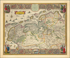
Antique map showing the area of the Burgundian Circle, published for Beschreibung des gantzen Welt-Kreises, the German edition of Mallet's Description de l'Univers.
Northeastern France and the Low Countries are shown. The Archbishoprics of Cologne, Mainz, and Trier, Palatinate, and Switzerland line the eastern border. The cities of Breda, Brussels, and Besançon are included.
Alain Mannesson Mallet (1630-1706) was a French mapmaker and engineer who served in the armies of Louis XIV. After rising through the ranks, Mallet was appointed as Inspector of Fortifications, a job which also required mathematical skills and which made him a competent military engineer. Eventually, he joined the court of Louis XIV at Versailles, where he taught math and focused on writing.
Mallet is best known for his Description de L’Univers, first published in 1683, in five volumes. A wide-ranging geographical work, the Description included textual descriptions of the countries of the world, as well as maps of the celestial sky and the ancient and modern worlds. The Description continued to be published until the early eighteenth century. He also published a work in three volumes on warfare (1684) and a primer on geometry (1702).


![[Set of 5 D-Day Maps of Normandy] Les Pieux Guernsey, Cherbourg-Valognes, Avranches-Fougeres, St.-Lô-Vire, Caen-Falaise](https://storage.googleapis.com/raremaps/img/small/93936.jpg)