|
||

|

|
|

|
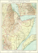
Africa Orientale Eritrea - Etiopia (Abissinia) - Somalia, a detailed cartographic representation of East Africa, specifically focusing on Eritrea, Ethiopia, and Somalia, was produced by the cartographic office of the Touring Club Italiano (T.C.I.), under the chief cartographer P. Corbellini, and printed by A. Vallardi in Milan. The map features Italian orthography for Ethiopian place names, indicating significant elements such as important and less important railways, planned railways, roads, caravan routes, wells, springs, water places, probable river courses, swamps, and vadi (riverbeds), and it includes an inset of Eritrea and another of the Somali coast south of Mogadishu.
During the period of Italian colonial rule in East Africa, which included the territories of Eritrea, Ethiopia (then known as Abyssinia), and Somalia, maps such as this one served as crucial tools for administrative, military, and infrastructural purposes. They gave Italian authorities a comprehensive view of these regions, aiding in resource allocation, strategic planning, and control over the territories. The decision to use Italian orthography for Ethiopian place names reflects the assimilative ambitions of the colonial power.
The map's depiction of infrastructure like railways and roads, both existing and planned, offers insights into the colonial administration's developmental plans and priorities. Notably, it also marks out natural features such as water sources, river courses, and swamps, highlighting the region's geographical diversity and the logistical challenges it posed.
In the broader historical context, Africa Orientale Eritrea - Etiopia (Abissinia) - Somalia stands as a significant object of the Italian colonial period in East Africa. While it reflects the utilitarian motivations behind its creation, it also serves as a window into the landscapes, infrastructures, and to some extent, the socio-political realities of a historically significant era. The inclusion of insets focusing on Eritrea and the Somali coast further adds to the depth and geographical coverage of this invaluable cartographic piece.
![[ The Search for the Source of the Nile ] Nouvelle Carte du Bassin du Nil indiquant la commune origine de ce Fleuve avec les Rivieres du Zanguebar Dressee et Dediee A La Colonie Europeene D'Orient . . . 1858](https://storage.googleapis.com/raremaps/img/small/96196.jpg)
![IX. b [East Africa]](https://storage.googleapis.com/raremaps/img/small/93300.jpg)
![[Timbuktu and Environs] Carte de la region de Tombouctou au 1/500,000.e Dressee par Mr. le Lieutenant Vaisseau Hourst, Commandant la Flottile du Niger et Mr. le Lieutenant Bluzet de l'Infanterie de Marine d'apres la carte Caron et Lefort, les travaux des officiers de la flottille, les itineraires et renseignements des officiers de la region. Publiee par la Societe de Geographie de Paris en Aout 1895. . .](https://storage.googleapis.com/raremaps/img/small/65023.jpg)