|
||

|

|
|

|
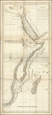
Colonia Eritrea is an interesting Italian colonial map published by Antonio Vallardi in Rome, Milan, and Naples in 1895. Designed to support colonial military operations, this map provides a detailed geographic representation of the Italian colony of Eritrea, with a scale of 1:700,000.
At the time of publication, Italy was expanding its colonial holdings in northeast Africa, and the establishment of the Eritrean colony played a vital role in this endeavor. The map serves as a testament to Italy's imperial ambitions and its desire to assert influence and control in the region.
The main map of the Colonia Eritrea focuses on the territory itself, providing detailed geographic and topographic information. It was specifically designed to aid military operations, highlighting strategic locations, transportation routes, and other relevant features that would be of significance in times of conflict.
Accompanying the main map is an inset titled "Possessi, Protettorati, Sfera d'influenza Italiana in AFRICA," designed by Dr. S. Losio. This inset presents a broader perspective of Italian interests in Africa, showcasing the extent of Italian possessions, protectorates, and areas of influence. The scale of this inset is 1:8,000,000, allowing for a broader regional context to be understood.
Colonia Eritrea not only provides valuable geographic and military information but also reflects the geopolitical dynamics of the time. The delineation of borders and areas of influence represents the complex relationships between Italy and other European powers, particularly regarding colonial expansion in Africa. This map stands as a significant historical document, shedding light on Italy's colonial aspirations and their impact on the African continent during the late 19th century.


![Italia '90 14-й чемпионат мира по футболу. [FIFA World Cup]](https://storage.googleapis.com/raremaps/img/small/89590.jpg)