|
||

|

|
|

|
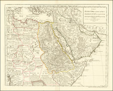
Dtailed map showing the route taken by Solomon's fleets on their three-year voyages, starting from the Gulf of Elan to go to Ophir and Tarshish.
The map illustrates the likely maritime routes purportedly used by the biblical King Solomon's fleets. According to biblical accounts, these fleets embarked on extensive voyages that lasted three years, starting from Ezion-Geber (near the Gulf of Aqaba, referred to as the Gulf of Elan in the text) to the distant and somewhat mythical lands of Ophir and Tarshish, which were famed for their riches and exotic goods.
The map was issued in a French edition of James Bruce's Travels to Discover the Source of the Nile, first published in 1790 in London. James Bruce was a Scottish traveler and writer who, in the 18th century, undertook extensive voyages in North Africa and the Horn of Africa. His books detailed his adventures and findings during his explorations of the Nile River.
The map served to support a discussion or theory Bruce had regarding the ancient sea voyages described in biblical texts, such as those undertaken by King Solomon's fleet. Bruce's works often included detailed engravings and maps to complement his vivid descriptions of the landscapes and peoples he encountered on his travels. The map indicating the route of Solomon's fleets to Ophir and Tarshish would thus be an attempt by Bruce to visualize ancient trade routes and navigation methods based on his understanding and the scholarly knowledge of his time.
![(East Africa) Zanguebar [Zanzibar]](https://storage.googleapis.com/raremaps/img/small/98173.jpg)