


|
||

|

|
|

|
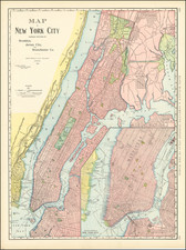
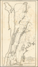
The Rand-McNally New Commercial Atlas Map of Brooklyn, produced by Rand-McNally & Co. in 1912, delineates the urban landscape of Brooklyn and its surrounding vicinities, featuring notable designations for elevated rapid transit, streetcars, parks, and parkways.
Historically contextualized, this map's production situates it in the heart of Brooklyn's burgeoning urban development, an era characterized by immense growth in its transportation network. Elevated rapid transit lines and streetcars were increasingly being constructed to facilitate the burgeoning population's mobility, reflecting the dynamic social and economic changes Brooklyn was undergoing during this time. The map's year of production, 1912, marks an era of transition as Brooklyn was integrating itself more fully into the broader fabric of New York City following the unification of the five boroughs in 1898.
This map provides a detailed depiction of the Brooklyn borough, outlining the topography of a city that was rapidly changing with the influx of immigrants and the construction of new infrastructures. The delineation of parks and parkways, vital recreational and social spaces in the urban environment, serves to highlight the foresight and planning of city administrators in catering to the city's evolving social needs.
From a cartographic perspective, the Rand-McNally New Commercial Atlas Map of Brooklyn serves as an important resource for understanding the development of Brooklyn's urban morphology at the beginning of the 20th century. Not only does it document the transportation arteries vital for city life, but it also preserves a snapshot of an era of exponential growth, both demographically and structurally, in one of the most iconic cities of the United States.
Rand McNally & Co. is a large American map and navigation company best known for its annual atlases. The company got its start in 1856, when William Rand opened a print shop in Chicago. He was joined in 1858 by a new employee, Andrew McNally. Together, the men established their namesake company in 1868. Originally, the company was intended to print the tickets and timetables for the trains running to and through Chicago; their first railway guide was published in 1869.
By 1870, they had shifted from just printing to publishing directories, travel guides, and newspapers. Their first map appeared in 1872 in a railway guide. The map was produced using a new wax engraving method, a cheaper process that gave the company an edge.
By 1880 Rand McNally had entered the education market with globes, wall maps, and geography texts for students. In 1923, Rand McNally published the first Goode’s World Atlas, named after its editor, Dr. J. Paul Goode. For generations afterward, this would be the standard classroom atlas.
In 1899, William Rand left the company, but McNally and his family remained, controlling the company for over a century. In 1904, they published their first road map intended for automobiles and by 1907 were publishing Photo-Auto Guides, which combined photography and mapping to help drivers. In 1924, they produced the Auto Chum, a precursor to their famous road atlases. Rand McNally would remain the leader in road maps and atlases throughout the twentieth century.
In 1937, Rand McNally opened its first store in New York City. Ever on the frontier of technology, Rand McNally pioneered the scribing process for printing tickets in 1958 and printed their first full-color road atlas in 1960. Arthur Robinson developed his now-famous projection of Rand McNally in 1969. By the 1980s, the company was exploring digital reproduction and digital databases of maps for truckers. In the 1990s, they lead the charge to develop trip-planning software and websites. Today, most of its products are available online or in a digital format, including maps for tablets and phones.
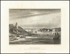
![Vereinigte Staaten von Nord-Amerika [Views of New York City and Back Country Scenes]](https://storage.googleapis.com/raremaps/img/small/25442.jpg)