


|
||

|

|
|

|
A Pair of Celestial Rarities By The Dutch Isaac Newton
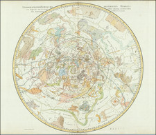
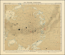
Extremely rare and unusually large pair of celestial hemispheres, which were the work of a collaboration of notable Dutch astronomers and the Van Keulen publishing house, and most notably, the Dutch prodigy Pieter Niewland.
In the rich tapestry of cartographic history, some maps are not just notable for their geographical detail but also for their artistic and scientific significance. Among these, the extremely rare pair of separately issued maps of the Northern Sky and Southern Sky, published by originally conceived by Pieter Nieuwland and ultimately published by Gerard Hulst Van Keulen in Amsterdam, are masterpieces that capture the vastness of the cosmos from an 18th-century perspective.
Illustrating the modern constellations of both hemispheres, these maps are a confluence of careful observation, precise calculation, and elegant artistry. They serve not only as astronomical tools but also as chronicles of the time's understanding of the heavens.
The genius behind the original designs of these celestial maps was Pieter Nieuwland (1764-1794). Nieuwland, often referred to as the "Dutch Isaac Newton", was a polymath excelling in various fields from nautical science to poetry. Recognized as a child prodigy, his insights and talents in chemistry, mathematics, and especially astronomy were unparalleled during his time.
However, these maps' existence is tinged with a touch of tragedy and the perseverance of those who followed in Nieuwland's footsteps. While he conceptualized the design, Nieuwland's untimely death at the age of 30 meant the maps were ultimately completed by Dutch mathematician and astronomer Jan Frederik Van Beeck Calkoen. His interactions included eminent personalities like Bernhard von Lindenau, the astronomer Johann Elert Bode, and numerous other leading scholars of the era, including Franz Xaver von Zach (see below).
The observations that form the basis of these celestial illustrations are a testament to the collaborative spirit of the scientific community of the era. Data was gathered from multiple renowned observatories. Notably, the Felix Meritis Observatory in Amsterdam, which had only recently been completed, played a pivotal role. Additionally, observations from the Leiden Observatory and the observatory of Count Franz Xavier von Zach in Gotha, to which Nieuwland traveled in the summer of 1792, contributed to the maps' precision and depth. This latter relationship likely resulted Jan Frederik Van Beeck Calkoen's becoming involved in completing the work, as Van Beeck Calkoen has spent significant time time in Gotha, where he frequented the observatory of Duke Ernst II of Saxe-Gotha-Altenburg and forged a long time relationships with its director Franz Xaver von Zach.
Beyond their scientific merit, the maps are also artefacts of the era's broader cultural movements. They were crafted during the Enlightenment, a period marked by an unquenchable thirst for knowledge, where science and art often intermingled. Thus, while they offer an insight into the known constellations, they also showcase the era's aesthetic sensibilities, with intricate illustrations that transform scientific observation into visual art.
Jan Frederik Van Beeck Calkoen also translated and posthumously edited Pieter Nieuwland's Verklaring der Gronden van de Zeemans Tafelen van Cornelis Douwes, Of der manier om uit twee waargenome Hoogten der Zon buiten den Middag, de Breedte eener Plaats te vinden. Uit het Hoogduitsch vertaald, en met Aanmerkingen uitgegeeven. (Explanation of the Foundations of the Sailor's Tables by Cornelis Douwes, or the method to find the Latitude of a Place from two observed Altitudes of the Sun outside of noon), which was published by Gerard Hulst van Keulen, in Amsterdam in 1800.
Rarity
The maps are extremely rare.
We note only the example at the University of Utrecht (uncolored). As noted below, the maps were likely intended for inclusion in Jan Frederik van Beeck Calkoen's 1798 Treatise ... published by Van Kuelen, but the examples located at the University of Utrecht and University of Amsterdam seemingly lack the plates.
A note with the Utrecht copies states that the maps were:
"Published in: Jan Frederik van Beeck Calkoen, 'Verhandeling over de manier om door waarneming van twee sterren op een gelyke doch onbekende hoogte, de middelbaare en waare tyd te vinden: Benevens de tafelen welke hier toe vereischt worden, geschikt ten dienste der Nederlandsche zeelieden' (Amsterdam: Gerard Hulst van Keulen, [1798]) (pl. II)./ This map of the southern starry sky (and the corresponding map of the northern starry sky) was originally designed by Pieter Nieuwland (1764-1794), but due to his premature death, it had to be completed and published by Jan Frederik van Beeck Calkoen (1772-1811)./ At the bottom of the map, it is noted: 'NB. an announcement regarding the use of this Plan is to be included with this.'"
The Van Keulens were a family of chartmakers and publishers. The firm, In de Gekroonde Lootsman (In the Crowned Pilot), was founded in 1678 by Johannes van Keulen (1654-1715). Van Keulen originally registered his business as a vendor of books and instruments (specifically cross-staffs). In 1680, however, he gained a privilege from the States of Holland and West Friesland for the publication of pilot guides and sea atlases.
In that year, van Keulen released his Zee-Atlas (Sea Atlas), which secured him a name in the competitive maritime publishing market. In 1681, he published the first volume of Nieuwe Lichtende Zee-Fakkel (New Shining Sea Torch). This would be the first of an eventual five volumes originally published between 1680 and 1684. A sixth volume was added in 1753. The Zee-Fakel won van Keulen lasting fame. The atlas had charts compiled by Claes Jansz Vooght and artwork from Jan Luyken. It proved immensely popular and was reprinted until 1783. There were translations in French, English, Spanish, and Italian.
The late-seventeenth century was an auspicious time to enter the maritime chart business. Previous industry leaders had either closed shop, died, or retired, leaving space for a new competitor. Van Keulen proceeded to buy up the stock and privileges of several maritime publishing firms; the most notable was the stock of Hendrik Doncker, acquired in 1693.
Johannes’ son, Gerard (1678-1726) took over the business upon his father’s death. Gerard was a skilled engraver and mathematician. His talents were noticed, as in 1706 he was named as Hydrographer to the Dutch East India Company (VOC).
In turn, Gerard’s son Johannes II (1704-1770) came to run the shop. He was also tied to the VOC, and his role as their chartmaker allowed his charts to be considered as quasi-official government documents. It is with access to formerly clandestine VOC geographic knowledge that Johannes the Younger was able to add a sixth volume to the Zee-Fakkel, which covered the East Indies. Johannes also continued to sell instruments, including the recently-invented Hadley’s Quadrant from 1744.
When Johannes II died in 1770, his widow ran the business in his stead, aided by her two sons, Cornelis Buys (1736-1778) and Gerard Hulst (1733-1801). Now a century old, the family business had extended to include an anchor factory. After Cornelis died in 1778, Gerard took on the management of the firm alone. He oversaw the introduction of sextants to their inventory and published the Dutch Nautical Almanac beginning in 1788. Annual editions appeared until 1885. Gerard also served as an original member of the Dutch Commission for Longitude at Sea from 1787.
Gerard’s widow ran the business for nine years after his death, when their son, Johannes Hulst, started to lead the firm in 1810. After his death in 1844, the firm passed out of family hands and into the control of Jacob Swert, a skilled cartographer who had worked for the business for two decades. He passed the work to his son, another Jacob, in 1866. By the mid-nineteenth century, the conversion from sail to steam had diminished the size of the market for charts. Fewer sailors needed fewer maps, charts, and instruments. In 1885, after 207 years in business, In de Gekroonde Lootsman closed its doors and auctioned its stock.
![Planisphere pour Servir a L'Explication de L'Apocalypse [No. 20]](https://storage.googleapis.com/raremaps/img/small/81787.jpg)
![[ The Ptolemaic Universe ] Situs Terrae Circulis Coelestibus Circundatae . . .](https://storage.googleapis.com/raremaps/img/small/101512.jpg)