


|
||

|

|
|

|
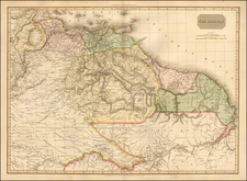
Nice example of De Jode's important early map of South America, based largely upon Petrus Plancius' wall map of the World, published in 1592.
De Jode's map of South America is one of the earliest maps to show the continent of South America alone and the earliest Dutch map of South America. The map provides a fine detailed treatment of the known and explored regions of South America, which had been heavily mapped and explored by the Spanish and Portuguese by the late 16th century.
The map is among the very few maps which reference the Straits of Magellan with its earlier name, Estrecho de la Victoria. The name was used by Pigafetta in his description of Magellan's voyage, named for Magellan's flagship, which illustrated to the west of the Strait. The map also includes detailed information and annotations on the Unknown Southern Continent. The information includes a number of place names and annotations.
In the interior parts of South America, the larger river systems are shown, along with annotations describing the regions, flora and fauna. The map reached to Central America and the Caribbean, embellished with ships and sea monsters around the continent.
De Jode's map includes a finely detailed treatment of the coastal regions of the continent, along with a number of fanciful features in the interior, including decorative vignettes, native scenes, and animals.
This was De Jode's second map of South America and was preceded by his Americae Peruvi . . . , published in 1578.

![[ South America ] Carte Encyprotype, de l' Amérique Meridionale . . . 1816 [Wall Map]](https://storage.googleapis.com/raremaps/img/small/69010.jpg)
![(Malaspina Expedition): [Group of six manuscript documents, signed, related to a future assignment for the officers of the Malaspina expedition, including a voyage to chart the coast of Guatemala and to explore Nicaragua, proposed by the viceroy of New Spain]](https://storage.googleapis.com/raremaps/img/small/101838.jpg)