|
||

|

|
|

|
The Olaf P. Jenkins Copy -- Pastedown Label of the 16th International Geological Congress
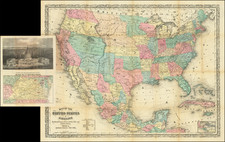
Fine example of this mammoth 4 sheet geological map of the United States, owned by one of America's foremost geologists.
The late 1920s and early 1930s marked an era of increased focus on scientific exploration and understanding, and amidst this background, the Geologic Map of the United States was published under the esteemed directorship of W.C. Mendenhall. This map, produced by the United States Geological Survey, is emblematic of the meticulous geological work and categorizations that were being undertaken during this time.
The map employs a systematic, albeit simplified, color scheme, which, although streamlined, maintains fidelity to geological accuracy. This approach, while effective in visual representation, necessitates a close reference to the accompanying legend to decipher specific nuances. In particular, the same color or pattern might denote units that are related but not identical. This choice of representation, while potentially challenging for the layman, allows for a concise yet informative portrayal of the vast geological diversities present in the United States.
An important feature of the map is its presentation of faults, with heavy lines marking these significant geological formations. The distinction between types of faults—whether normal faults or overthrusts—is clearly delineated, further exemplifying the map's commitment to providing a thorough and precise understanding of the geology it presents.
The map's legend and symbolization are extensive, aiming to provide clarity in a field riddled with complexity. The symbology employed, especially the nuanced differentiation between geological systems or series using capital letters, is particularly noteworthy. Additionally, the nuanced approach to mapping units from the Tertiary system, often using additional lowercase letters, underscores the depth of categorization and the commitment to precision inherent in this monumental work.
Lastly, one must consider the logistical feat of the map's production. Comprising four sheets, each with its distinct legend pertaining to a specific region, the map necessitates careful cross-referencing. This structure, while perhaps demanding for the user, reflects an era when scientific endeavors were valued not just for their informative capacity, but also for their methodological rigor and integrity.
Olaf Pitt Jenkins: A Pioneer of California Geology
Born on February 9, 1889, in Greencastle, Indiana, Olaf Pitt Jenkins would become a pivotal figure in the understanding and mapping of California's geological landscape. In 1891, his family had relocated to Stanford University, California, where his father, Professor Oliver Peebles Jenkins, began his tenure at Stanford's Department of Physiology.
Growing up in the academic environment of Stanford, Olaf was influenced by his father's association with the sciences. In 1904, he joined a Stanford-led scientific journey to the Sierra Nevada to study the golden trout.
Olaf's trajectory into geology became clear during his involvement with Robert Anderson and Robert Pack of the U.S. Geological Survey. As a member of their team, Jenkins contributed to the groundbreaking mapping of the western rim of the San Joaquin Valley. This formative experience, combined with his work on the Kreyenhagen Shale, solidified his dedication to the field.
In 1911, Jenkins ventured to Brazil as part of the J.C. Branner scientific expedition. Post-graduation in 1913, he traveled to Tennessee to assist the state geologist. He returned to Stanford for his master's degree in 1915. He also spent time in the private sector with the Gypsy Oil Company and later taught geology at Washington State College.
He earned his Ph.D. at Stanford and, in 1929, was appointed chief geologist of the Geologic Branch of the State Division of Mines in San Francisco, where he turned a primarily statistical bureau into one of the leading state geological surveys, pioneering a comprehensive state geologic map, crucial studies on petroleum geology, and various other influential publications.
![[Important Early Geology Maps] Tableau du Climat et du Sol des Etats-Unis D'Amérique. Suivi d'éclaircissemens sur la Floride, sur la colonie Française au Scioto, sur quelques Canadiennes et sur les Sauvag . . .](https://storage.googleapis.com/raremaps/img/small/69358.jpg)