|
||

|

|
|

|
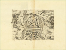
Braun & Hogenberg's birdseye view of Budapest, titled "Buda Citerioris Hungariae Caput Regni Avita Sedes - vulgo Ofen" (Buda, the ancient seat of the kingdom and capital of present-day Hungary – commonly called Ofen), published in 1617, presents a detailed depiction of Budapest during the period of Turkish occupation.
The illustration divides Budapest into its two key parts: Buda, with its notable hilltop fortress and royal palace, situated across the Danube, and Pest, with its distinct fortifications, on a hill on the other side of the river. A pontoon bridge connects the two, emphasizing the unity between them. The Turkish occupation's architectural impact is evident. Several former churches are shown as mosques, identifiable by their domes, reflecting the religious changes of that era.
In the forefront, the depiction of the local Ottoman pasha accompanied by his delije (bodyguard) stands out. The delije, illustrated with feathers inserted into the skin of their scalp, represents the specific cultural practices and the fierceness attributed to these guards. The transcription of the places listed at the view's bottom is as follows:
- A. Propugnaculum novum: The new fortress.
- B. Arx et Palatium Regium: The fortress and the Royal Palace.
- C. Templum olim Diue Virginis nunc Mefkita: Formerly a temple of the Holy Virgin, now a mosque.
- D. Colles viniferi: Wine-producing hills.
- E. Baßa Budenfis: The Pasha of Buda.
- F. Genus Hominum apud Turcas Barbarum... Communicauit Georgius Houfnaglius Anno 1617: Describes a group of Turks known for their audacity and fierceness, with a reference to further descriptions by Johannes Lewenclau and credits to Georgius Houfnaglius for the information in 1617.
Johannes Lewenclau (aka Johann Lewenklaw) was a 16th-century writer and scholar. He is most renowned for his works related to the Ottoman Empire, which provide insights into Turkish customs, culture, and military practices.
Georg Braun (1541-1622) was born and died in Cologne. His primary vocation was as Catholic cleric; he spent thirty-seven years as canon and dean at the church St. Maria ad Gradus, in Cologne. Braun was the chief editor of the Civitates orbis terrarum, the greatest book of town views ever published. His job entailed hiring artists, acquiring source material for the maps and views, and writing the text. In this role, he was assisted by Abraham Ortelius. Braun lived into his 80s, and he was the only member of the original team to witness the publication of the sixth volume in 1617.
Frans Hogenberg (ca. 1540-ca. 1590) was a Flemish and German engraver and mapmaker who also painted. He was born in Mechelen, south of Antwerp, the son of wood engraver and etcher Nicolas Hogenberg. Together with his father, brother (Remigius), uncle, and cousins, Frans was one member of a prominent artistic family in the Netherlands.
During the 1550s, Frans worked in Antwerp with the famous mapmaker Abraham Ortelius. There, he engraved the maps for Ortelius’ groundbreaking first atlas, published in Antwerp in 1570, along with Johannes van Deotecum and Ambrosius and Ferdinand Arsenius. It is suspected he engraved the title page as well. Later, Ortelius supported Hogenberg with information for a different project, the Civitates orbis terrarium (edited by Georg Braun, engraved by Hogenberg, published in six volumes, Cologne, 1572-1617). Hogenberg engraved the majority of the work’s 546 prospects and views.
It is possible that Frans spent some time in England while fleeing from religious persecution, but he was living and working in Cologne by 1580. That is the city where he died around 1590. In addition to his maps, he is known for his historical allegories and portraits. His brother, Remigius, also went on to some fame as an engraver, and he died around the same time as his brother.

![[Composite Lafreri-style Atlas of Battle Plans and Fortifications]](https://storage.googleapis.com/raremaps/img/small/92702.jpg)