The item illustrated and described below is sold, but we
have another example in stock. To view the example which
is currently being offered for sale, click the
"View Details" button below.


|
||

|

|
|

|
Stock# 95737
Description
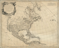
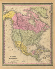
Highly detailed map of North America, published by Thomas Cowperthwait & Co.
First issued by Thomas Cowperthwait in 1850, the map has been updated to show several important territorial and boundary changes:
- Post-Gadsden Purchase border with Mexico (1854)
- Nebraska Territory shown (first began to appear in 1853)
- Kansas Territory shown (Kansas–Nebraska Act of 1854)
- Washington Territory shown (formed March 2, 1853)
Washington and Oregon Territory still extend to the Rocky Mountains.
Nebraska Territory extends to Canada, including Montana, Wyoming and part of the Dakotas.
Kansas Territory covers the eastern half of the future Colorado Territory.
Massive Utah and New Mexico Territories extend to and beyond the Rocky Mountains.
![Johnson's North America [with Inset of Hawaii]](https://storage.googleapis.com/raremaps/img/small/88883.jpg)