|
||

|

|
|

|
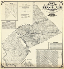
Highlighting The Belgian St. Thomas District, Flag of Poyais and other American Oddities
Fascinating map of North America, adorned with the seals and flags of a number of nations in the region.
Among the flags, some of the more interesting include:
- Texas (a curious depiction of the Lone Star Flag, which looks more like the flag of Liberia)
- Russian American Company (which controlled Alaska until 1867)
- Poyais (Belize) (the state of Poyais was promoted in the 1820's by General "Sir" Gregor MacGregor as a means of raising fraudulent loans -- see below)
Cartographically, the map would seem to date to about 1867, as the Territory of Montana is shown, but not the Territory of Wyoming. Nevada, Arizona and Idaho also appear, along with "Dagota" Territory. The route of the first transcontinental railroad is shown, with the proposed route of the Southern Pacific dipping into a pre-Gadsden Purchase Mexico.
The large inset of the California Gold region is drawn from the map of Duflot de Mofras.
The History of St. Thomas District in Guatemala: A Belgian Chapter
The inset of St. Thomas tells an interesting story of the history of Guatemala. In 1844, under the directive of King Leopold I of Belgium, a ship anchored off the coast of southern Izabal, Guatemala. The Belgians, under notable colonists such as Jean-Baptiste Corsange and Henri van der Elst, settled in Santo Tomás de Castilla, forging an uncommon alliance with the Guatemalan government.
With an agreement sealed with the President of Guatemala, the Belgians were granted the St. Thomas District in perpetuity, in return for an annual payment of sixteen thousand pesos. This settlement came with stipulations: the Belgians had to adopt Catholicism and Guatemalan citizenship but were allowed a semi-autonomous government. The Belgians' commitments extended beyond mere finances. They pledged significant infrastructural developments, including constructing a metal bridge over the Motagua River and establishing a port in the Bay of Amatique.
The colony, experiencing steady growth, underwent a pivotal change in 1877. The District of St. Thomas was officially sold to the Belgian government, turning it into a recognized colony. This transaction also transferred the responsibility of the annual payment to the Belgian state. This Belgian chapter in Guatemalan history serves as a testament to the intricate interplay of colonization, religion, and geopolitical aspirations during the 19th century.
The Poyais Scheme: A Brief History
The story of Poyais is one of the most audacious and infamous hoaxes in the annals of colonization. At its heart was Gregor MacGregor, a Scottish soldier and adventurer. In the early 1820s, MacGregor began promoting the land of "Poyais," allegedly located near the Mosquito Coast of present-day Honduras and Nicaragua. He painted a picture of a fertile and mineral-rich land, with established infrastructure, ready for British settlers to inhabit and prosper. Armed with forged documents, detailed maps, and even a fabricated guidebook, MacGregor managed to secure significant loans in London and attracted around 250 settlers to invest their fortunes and futures in Poyais.
In 1822, two ships departed Britain bound for Poyais. Upon their arrival, settlers found no bustling capital city, no infrastructure, and none of the promises MacGregor had assured them of. Instead, they found uninhabitable wilderness. Many settlers fell ill and died due to tropical diseases and inadequate provisions. By 1823, news of the Poyais hoax reached Britain. Of the initial 250 settlers, only around 50 managed to return home. MacGregor's deception was uncovered, but he managed to escape justice by moving to France, where he attempted similar scams before eventually settling in Venezuela.
Philippe Marie Vandermaelen (1795-1869) was a Belgian cartographer and geographer known for his pioneering use of technology and his leadership in establishing the important Establissement geographique de Bruxelles. Born in Brussels, Philippe was obsessed with maps from a young age. He taught himself mathematics, astronomy, and mapmaking and plotted the battles of the Napoleonic wars avidly. He took over his father’s soapmaking business briefly in 1816, but then turned it over to his brother in favor of cartography.
From 1825 to 1827, he released his first atlas, the Atlas universal, which was well received. It was sold in forty installments of ten maps each, with 810 subscribers listed. The atlas contained 387 maps in six volumes at a uniform scale of 1:1.6 million. The maps were intended to be joined and together would create a globe 7.755 meters wide. It was the first atlas to show the entire world on a large uniform scale and was the first atlas produced using lithography. This project served as Vandermaelen’s gateway into intellectual life, gaining him membership in the Royal Academy of Sciences and Belles-Lettres of Brussels (1829).
In 1830, Vandermaelen inherited a laundry from his parents which he converted into the Establissement geographique de Bruxelles, or the Brussels Geographical Establishment. His brother, Jean-Francois, also established a botanical garden on the site. The Establishment had its own lithographic press, one of the first to use the technology for cartography and the first in Belgium. They produced textbooks, surveys, and especially maps of Brussels to be used for urban planning. The complex also housed schools, an ethnographic museum, and a library open to the public. Vandermaelen was passionate about geographic education and saw the Establishment as an open place where people could learn about the world.
In 1836, he was knighted for his services to geography and the intellectual community of Belgium. He died at age 73 in Molenbeek-Saint-Jean, near the Geographical Establishment that he founded. After Vandermaelen’s death, the Geographical Establishment declined, closing its doors in 1880. The extraordinary collection they had amassed passed to several institutions, most importantly the Royal Library of Belgium.
![[Pan American Menu Map] North America](https://storage.googleapis.com/raremaps/img/small/103976.jpg)