|
||

|

|
|

|
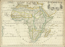
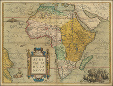
Africa, engraved by Herman Moll and published in London in 1695, is a significant representation of the African continent drawn from Moll's renowned Thesaurus Geographicus. With a discernible influence from the traditional Blaeu 1617 folio map, Moll, in this publication, opted for conservativeness over adopting the more recent French cartographic innovations. This is the second map of Africa ascribed to Herman Moll, following his collaborative effort with Moore in 1681.
During the latter part of the 17th century, European cartography was undergoing an evolution, with French cartographers leading the way in introducing more contemporary and detailed depictions of various regions. Moll's decision to adhere to the Blaeu 1617 model, which by 1695 had become somewhat antiquated, was an intentional choice rooted perhaps in a reverence for traditionalist representations or skepticism towards more recent French designs.
This map's significance and reliability are emphasized by its recurring appearances in subsequent editions and works by Moll, such as A System of Geography in 1701, The Compleat Geographer in multiple editions, and Atlas Manuele throughout the early 18th century. Although the map itself remained consistent, variations in textual content and page arrangements provide differentiation across editions.
Herman Moll (c. 1654-1732) was one of the most important London mapmakers in the first half of the eighteenth century. Moll was probably born in Bremen, Germany, around 1654. He moved to London to escape the Scanian Wars. His earliest work was as an engraver for Moses Pitt on the production of the English Atlas, a failed work which landed Pitt in debtor's prison. Moll also engraved for Sir Jonas Moore, Grenville Collins, John Adair, and the Seller & Price firm. He published his first original maps in the early 1680s and had set up his own shop by the 1690s.
Moll's work quickly helped him become a member of a group which congregated at Jonathan's Coffee House at Number 20 Exchange Alley, Cornhill, where speculators met to trade stock. Moll's circle included the scientist Robert Hooke, the archaeologist William Stuckley, the authors Jonathan Swift and Daniel Defoe, and the intellectually-gifted pirates William Dampier, Woodes Rogers and William Hacke. From these contacts, Moll gained a great deal of privileged information that was included in his maps.
Over the course of his career, he published dozens of geographies, atlases, and histories, not to mention numerous sheet maps. His most famous works are Atlas Geographus, a monthly magazine that ran from 1708 to 1717, and The World Described (1715-54). He also frequently made maps for books, including those of Dampier’s publications and Swift’s Gulliver’s Travels. Moll died in 1732. It is likely that his plates passed to another contemporary, Thomas Bowles, after this death.
![[ World & Continents ] Typus Orbis Terrarum / Americae Sive Novi Orbis Nova Descriptio / Asiae Nova Descriptio / Africae Tabula Nova / Europae](https://storage.googleapis.com/raremaps/img/small/99250.jpg)