


|
||

|

|
|

|
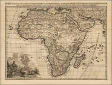
Rare separately published map of Africa, originally issued by JB Nolin and here "corrected and augmented" by Louis Denis in 1817.
The map offers a classical look at the known parts of Africa at the dawn of the 19th Century, along with text descriptions for the various regions of Africa, along with an interesting allegorical cartouche, which includes a teapot which appears to include the head of a snake.
Sample text sections translates as follows:
About Nigritia.
Nigritia is the land of the true Blacks, located in the middle of the lands along the Niger, of which little is known. It is only known that the most powerful kingdom is that of Timbuktu, whose capital is situated near the Niger; it is the most commercial area in this region, trading in Gold, Ivory, and Slaves. Among these peoples, some are Idolaters and others are Muslims."
About Abyssinia.
Abyssinia was formerly known under the general name of Ethiopia, of which it now occupies the main part. It is a vast region whose inhabitants are tall, robust, and more beautiful than the Negroes, very civilized; they are Schismatic Christians. There are countless Monks. The Prince is absolute, they have few Cities, their Monasteries and dwellings are spread over the Mountains and in the Valleys. The Southern Provinces are often ravaged by the Gallas, a cannibalistic people and cruel enemies of the Abyssinians.
About the Cafrerie.
It is a very vast Region extending from Nigritia in the Lands to the Cape of Good Hope, inhabited by a very large number of Peoples, most of whom are Cannibals such as those from the states of Macoce, Ginaire, and the Jagas. Some less barbaric are those from Monoemugi and Monomotapa; the latter is considered to be powerful and very rich in Gold. The Kaffirs located along the Coasts, such as the Hottentots, are extremely dirty, stupid, and barely form a few words or vocal sounds to make themselves understood among each other. The Dutch have a considerable Establishment at the Cape of Good Hope.
Jean-Baptiste Nolin (ca. 1657-1708) was a French engraver who worked at the turn of the eighteenth century. Initially trained by Francois de Poilly, his artistic skills caught the eye of Vincenzo Coronelli when the latter was working in France. Coronelli encouraged the young Nolin to engrave his own maps, which he began to do.
Whereas Nolin was a skilled engraver, he was not an original geographer. He also had a flair for business, adopting monikers like the Geographer to the Duke of Orelans and Engerver to King XIV. He, like many of his contemporaries, borrowed liberally from existing maps. In Nolin’s case, he depended especially on the works of Coronelli and Jean-Nicholas de Tralage, the Sieur de Tillemon. This practice eventually caught Nolin in one of the largest geography scandals of the eighteenth century.
In 1700, Nolin published a large world map which was seen by Claude Delisle, father of the premier mapmaker of his age, Guillaume Delisle. Claude recognized Nolin’s map as being based in part on his son’s work. Guillaume had been working on a manuscript globe for Louis Boucherat, the chancellor of France, with exclusive information about the shape of California and the mouth of the Mississippi River. This information was printed on Nolin’s map. The court ruled in the Delisles’ favor after six years. Nolin had to stop producing that map, but he continued to make others.
Calling Nolin a plagiarist is unfair, as he was engaged in a practice that practically every geographer adopted at the time. Sources were few and copyright laws weak or nonexistent. Nolin’s maps are engraved with considerable skill and are aesthetically engaging.
Nolin’s son, also Jean-Baptiste (1686-1762), continued his father’s business.
Louis Denis (1725-1794) was a French geographer and cartographer best known for his incomplete road atlas of France, Le Conducteur français. Originally trained as an engraver, he partnered with Louis-Charles Desnos to create and edit maps. Later, Denis served as geography tutor to the children of the French royal family. His pupils included the Duc de Berry, the future Louis XVI.
![[ Ancient World ] Christianographie](https://storage.googleapis.com/raremaps/img/small/80305.jpg)
![[ Atlantic Ocean / Triangular Trade / Negroland ]](https://storage.googleapis.com/raremaps/img/small/65187.jpg)