


|
||

|

|
|

|
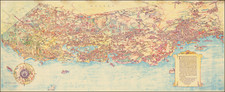
The Heart of the San Joaquin Valley
Fine large format cadastral map of Stanislaus County, California, published by the Stanislaus Land & Title Company.
Centered on the Tuolumne River and the San Joaquin River, and the city of Modesto, the map is remarkably detailed, listing showing schools, railroads, county and lesser roads, irrigation district boundaries, bridges, and host information.
This map provides a comprehensive overview of the heart of the Central Valley of California delineating private landholdings, cadastral section lines, Spanish land grants (ranchos), and municipal divisions. It includes detailed hydrographic elements, transportation networks comprising railroads and roads, as well as the locations of bridges, educational institutions, and the extents of irrigation jurisdictions.
Accompanying the primary map are five ancillary cartographic depictions of Ceres, Newman, Turlock, Modesto, and Oakdale.
The map is further enhanced with annotations pertaining to the historical surveys that determined Stanislaus County's perimeters, an exposition on the delineation of county supervisorial districts, and a selection of demographic data.
The map has been ratified by the county's governing body as the authoritative cartographic record of Stanislaus County as of July 10th, 1906.
Rarity
OCLC locates 1 copy at UC Berkeley.
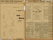
![[ San Diego County / Julian Mining District ] Sixth Annual Report of the State Mineralogist. Part I for the year ending June 1st 1886.](https://storage.googleapis.com/raremaps/img/small/101709.jpg)

![Nouvelle Carte Du Mexique, Du Texas Et D'Une Partie Des Etats Limitrophes . . . 1840 [Proposed Railroads In Texas -- First Appearance of Arizona on a Printed Map]](https://storage.googleapis.com/raremaps/img/small/103480.jpg)