|
||

|

|
|

|
Two Monumental Manuscript Maps of San Diego Bay, From the Tip of Point Loma to National City.
The Re-Mapping of the City With a New City Survey.
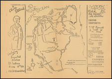
Phenomenal set of 1880s San Diego maps, hand-drawn and showing the nascent city's steady growth around the Bay.
The first of these two maps covers the stretch of land between the boundary with National City north to the San Diego River, Old Town, and the start of Point Loma. Along the way, neighborhoods, streets, public transportation, and many other features are marked. Many of the city's earliest additions are still named, including the Horton, and Manassee and Schiller Additions, with Old Town, Middle Town, and New Town all marked as well. The recently-built San Diego and Pacific Beach Railroad, which hadn't yet expanded to La Jolla, is seen following Arctic and Third Streets before disappearing off the map. The original Hay's Survey of the San Diego Pueblo, executed in 1859, is shown in black, while Schuyler's more recent survey is shown in blue.
The second map shows the region from Hay's Park around the peninsula to the tip of Point Loma. A small jut of the northernmost part of Coronado appears, labeled the "Peninsula of San Diego." The southwestern corner of the Point Loma Peninsula is itself given over to a "U.S. Military Reservation," although there are a few, apparently privately owned tracts scattered throughout. The Roseville Nailworks are shown in the New Roseville neighborhood.
These maps were apparently made as a rectification of previous, erroneous surveys which were made to much looser specifications. During this period, further infilling of the Bay was being considered, and a correct survey of the area was an important requisite for executing this correctly. Further, with the ever-growing addition of railroads in the downtown areas, accurate city surveys had to be conducted in conjunction with this development.
Several, probably later, pencil annotations dot the map, including a sketch of one small part of the Point Loma Railroad, which opened in 1910.
James Dix Schuyler: Canal Builder, Irrigation Specialist, and San Diego City Engineer
Schuyler (1848-1912) was a prolific West Coast engineer whose diverse enterprises spanned many states, countries, and fields. While perhaps his most notable achievement was accompanying President-Elect William Howard Taft on a tour of the Panama Canal, and reporting on his findings for Congress, much of his life was dedicated to building early California infrastructure.
Schuyler, a native of Ithaca, New York, started his engineering career in the Midwest in 1869 when he was employed in the service of the Kansas Pacific Railway. From there, he moved to California to work on railroads there, before being appointed Chief Assistant State Engineer in 1877. Following a brief stint in the Mexican railroad industry, Schuyler returned to California. One of his most important projects was the construction of the Sweetwater Dam in 1887-1888, about the time when he became City Engineer for San Diego. It was in this position that he would make the present resurvey of San Diego. In the early 1900s, Schuyler pioneered the construction of dams through hydraulic fill, and it was in part because of this expertise that he was sent, with President-Elect Taft, to Panama to advise on the construction of a lock system. He recommended substantial modifications to the Gatun Dam, which were acted upon.
Schuyler would die in 1912. His papers are preserved at UC Riverside.
![(Earliest Obtainable Map of San Diego Bay) Plan du Port De St. Diego en Californie. . . 1782 [with] Plan Du Port et du Departement de San Blas . . . 1777](https://storage.googleapis.com/raremaps/img/small/61850.jpg)
![(California Photographs) [Album of 112 original photographs: San Diego and Los Angeles area, including La Jolla - Coronado - Sunset Cliffs - Lake Cuyamaca - Cuyamaca Dam & Valley -- Tia Juana (San Ysidro) -- Raymond Hotel in Pasadena - Shasta - Lick Observatory - Seattle]](https://storage.googleapis.com/raremaps/img/small/98892.jpg)