|
||

|

|
|

|
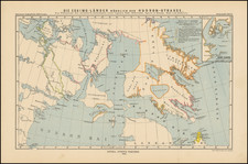
The South Polar Chart of 1905, drafted by cartographer Hans Fischer and published by the American Geographical Society, was prepared at a pivotal point in the cartographic representation of the Antarctic. It meticulously documents the early twentieth-century explorations, offering a detailed and scholarly record of the formidable Antarctic expeditions that marked the era.
The main map tracks the explorations of Robert Falcon Scott between 1902 and 1904 and Erich von Drygalski. In addition, there are dozens of discovery points listed on the map, setting for the name of the arctic discoverer and date, dating back to Bellinghausen in 1820-21 and James Cook in 1773 and 1775.
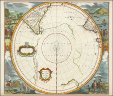
The map includes corner insets, each providing a focused examination of key expeditions. The first inset illustrates South Victoria Land as discovered by James Ross in 1841, with additional routes marked by Scott's expeditions from 1902 to 1904, showcasing the advancements in understanding this sector over sixty years. Scott's routes underscore the enduring commitment to exploration despite the region's treacherous conditions.
Inset two portrays Kaiser Wilhelm II Land, a territory first charted by Erich von Drygalski's German Antarctic Expedition in 1902. This section of the map includes the path of the Gauss, von Drygalski's expedition ship, detailing the coastal explorations conducted during 1902 and 1903. The geographical features identified by von Drygalski's team contributed significantly to the mapping of this remote area.
The third inset focuses on West Antarctica and the South Shetland Islands, highlighting the Swedish Antarctic Expedition led by Otto Nordenskjöld in 1902, and Jean-Baptiste Charcot's French Antarctic Expeditions. These explorations are marked by winter quarters and trails, reflecting the challenges faced by these explorers in the harsh polar climate.
The final inset centers on the Region of Mount Erebus and Terror, marking the Discovery Expedition's winter quarters and tracks. The Discovery Expedition, led by Robert Falcon Scott from 1901 to 1904, was a landmark British undertaking that aimed to carry out scientific research and geographical exploration, which this map excerpt commemorates with precision.
Each legend entry on the chart serves not only as a key to the cartographic symbols but also as an historical record of the endeavors undertaken in these frigid landscapes. The differentiation of ocean depths, the notations of pack ice, and the detailing of inland ice and glaciers articulate the formidable environment that these explorers encountered. Notably, the chart’s white spaces signify the vast unexplored territories, hinting at the limits of contemporary knowledge during the period.
The South Polar Chart remains a significant historical document, reflecting the synthesis of scientific endeavor and exploration. It is an objective record of human persistence and scientific inquiry during an age when Antarctica was the world's last great terra incognita.