|
||

|

|
|

|
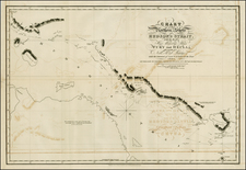
Detailed map of "The Eskimo Lands North of the Hudson Strait", illustrating the regions explored by several Arctic explorers in the Canadian Arctic.
The map is color coded to show the areas explored by each explorer, with the key at the top right.
Captain Charles Francis Hall's expeditions (1860-1869) were instrumental in searching for the lost Franklin Expedition and yielded rich ethnographic information through his interactions with the Inuit peoples. His work was crucial in charting parts of the previously unmapped Arctic regions.
Frederick Schwatka, an American explorer, led a significant expedition from 1878 to 1880 that resulted in the longest sledge journey of that time and greatly expanded the cartographic knowledge of the Canadian Arctic territories.
Thomas Spicer, participating in Schwatka's 1878-1880 expedition, contributed to the logistical and navigational success of the mission. His efforts were essential in the completion of the extensive sledge journey undertaken during the expedition.
Franz Boas, whose work in the Arctic occurred from 1883 to 1884, conducted extensive ethnographic and geographical research, particularly among the Inuit of Baffin Island. His studies provided a foundation for modern anthropology and expanded the understanding of the cultural landscapes of the Arctic.
August Heinrich Petermann (1822-1878) is a renowned German cartographer of the nineteenth century. Petermann studied cartography at the Geographical Art-School in Potsdam before traveling to Edinburgh to work with Dr. A. Keith Johnston on an English edition of Berghaus’ Physical Atlas. Two years later he moved to London, where he made maps and advised exploratory expeditions as they set off to explore the interior of Africa and the Arctic.
In 1854, Petermann returned to Germany to be Director of the Geographical Institute of Justus Perthes in Gotha. There, he was the editor of the Geographische Mittheilungen and Stieler’s Handatlas. The Royal Geographical Society of London awarded him their Gold Medal in 1860. He continued his interest in exploration in Germany, fundraising for the German Exploring Expeditions of 1868 and 1869-70, which sought an open Arctic sea. Tragically, he committed suicide in 1878.

![[Unique Extra-Illustrated Example!] Carte Nouvelle Contenant La Partie d'Amerique La Plus Septentrionale, . . . Le Canada ou Nouvelle France, La Nouvelle Ecosse, La Nouvelle Angleterre, Les Nouveau Pais Bas, La Pensylvanie . . . Et Jle. de Terre Neuve . . .](https://storage.googleapis.com/raremaps/img/small/47720.jpg)