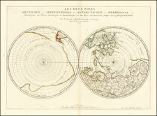
|
||

|

|
|

|
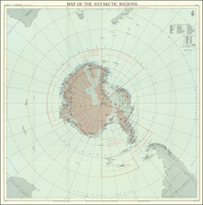
Antarctica, prepared by the American Geographical Society for the National Academy of Sciences in the lead up to the International Geophysical Year of 1957-1958, offers a detailed representation of the continent's geography. Displayed on a stereographic projection, the map provides a concise and objective depiction of Antarctica’s terrain, underlining the scientific advancements of its era.
The map was created during a period of intensified international cooperation in geophysical science. The International Geophysical Year exemplified an effort to extend human knowledge about the Earth, with a particular focus on regions as yet unstudied. In this environment, the map functions as both a resource and a record of the investigative processes and findings of the time.
Antarctica is notable for its detailed representation of the continent’s physical features. Elevations, depths, glaciers, and ice shelves are articulated precisely, providing a comprehensive view of the Antarctic landscape. The cautious annotation, evident in markings such as "Existence Doubtful" (ED) and "Position Approximate" (PA), reflects the careful and rigorous approach to the mapping of a largely uncharted territory.
An inset of the map, "Antarctica in Relation to the Other Continents," uses a polar azimuthal equal-area projection to situate Antarctica within the global context.
Moreover, the inset "Mapping the Antarctic" outlines the state of Antarctic exploration as of 1955, indicating the areas subjected to detailed surveys, reconnaissance, and aerial photography.
![[ Aurora Borealis ] Karte der Geographischen Verbreitung des Nordlichtes. Von H. Fritz](https://storage.googleapis.com/raremaps/img/small/98483.jpg)