|
||

|

|
|

|
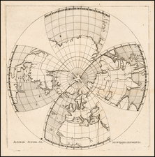
Fine Map of the Northern Hemisphere, With the Latest Russian Discoveries in the Northeast Asia
Striking north polar projection which includes the latest Russian discoveries in the North Pacific. This is a rare 1741 edition of this important map, originally by Guillaume Delisle, and published by Covens and Mortier in Amsterdam.
The map shows the entire Northern Hemisphere. The projection has the opposite effect of a Mercator projection, which tends to stretch and distort landmasses that are close to the poles. Here, it is territory close to the equator that is stretched, allowing the Arctic to come into sharp focus.
California is shown as a peninsula, although other contemporary maps still featured it as an island. Greenland is connected to Northern Canada in Baffin Bay, a common hypothesis at this time. Japan too is shown in what appears a rudimentary form; a more horizontal orientation of the archipelago was typical on maps until slightly later in the eighteenth century.
In the North Pacific, an unfinished island extends eastward. This Terre de la Compagnie is near Terre d’Yedso, an exaggeration of Hokkaido. Nearby, a note ties the former to the voyage of Dom Jean de Gama, who supposedly discovered a large coastline in the area. All three of these proved to be chimeras which shrank over the course of the century and eventually disappeared from maps.
The unfinished shores of North America and Greenland suggest that further exploration is necessary to better understand the Arctic. Indeed, the map seems to imply that there may be a navigable route north of Asia or around Baffin and Hudson’s Bay, a nod to the much-sought and still-elusive Northwest Passage.
One leader in the search for such a passage, and for a more detailed charting of northern waters, were the Russians. Two important expeditions, the first Russian naval expeditions focused minutely on geographic reconnaissance, helped to chart much of the Northeast Asian coast and proved that America and Asia were not connected. These voyages (1725-30, 1733-43), led by Vitus Bering, are referenced here in the letter that is translated into both Dutch and French in the bottom corners of the map.
This letter, dated January 13, 1740 (with the additional date of January 24, a nod to the fact that certain countries had not shifted from the Julian to the Gregorian calendar), was from a Monsieur Swartz residing in St. Petersburg. Swartz, a Dutch diplomat, was reporting news from the second Bering expedition. He recounts a letter from Martin Spanberg, a Danish naval officer in the Russian navy, who had served on both expeditions. Spanberg recounted his recent discovery of 34 islands, which he supposed were part of Japan. The letter had been delivered with a coin, which had Chinese or Japanese characters on it.
The first Bering expedition also explains why Russia looks remarkably complete for the time. One of the sources for this map was the 1734 map of the Russian Empire by Ivan Kirilov. This map, which is rare, was part of Kirilov’s larger project, the Atlas Russicus, the first Russian atlas. Kirilov’s map was the first scientifically accurate map of Russia and one of the earliest to include the results of the initial Bering expedition. These results are seen here in the shape of the Kamchatka Peninsula and the northeastern-most parts of Asia.
The map was originally published in 1714 by Guillaume Delisle. Covens and Mortier had the rights to print Delisle’s maps in the Netherlands. This state has an improved northeast corner of Asia, as well as the letter from Swartz.
One of the largest and best-organized voyages of exploration, the Great Northern Expedition completely remapped the Arctic coast of Siberia and some parts of the northwest coast of America. Vast amounts of hitherto unknown detail were filled in, which was previously represented following myth and speculation.
The idea of a land bridge from Siberia to America was long-held, appearing in maps since the fifteenth century and being the subject of academic speculation as to the origins of the indigenous peoples of America. To seek out the possibility of this land bridge, Peter the Great sent two unsuccessful land surveys to the area, before sending the First Kamatchka Expedition in 1725. This expedition made it slightly further than Cap Chutotsky and St. Lawrence island (now part of Alaska), and was celebrated as proving the absence of a land bridge between Russia and North America. This expedition made Bering, its commander, a national hero.
The logical next step was to try and reach North America. Empresses Anna and Elizabeth were both interested in continuing Peter the Great's legacy of exploration and sponsored a Second Kamatchka Expedition (1733-43). The expedition comprised of three separate groups; two divisions (one headed by Bering himself) crossed the Pacific, while an academic expedition explored Siberia. The academic interest in this expedition was great, and several leading scientists and geographers of the day were involved in its planning, including the cartographer Gerhard Müller.
This expeditions, later known as the Great Northern Expedition, filled in vast amounts of previously unknown coastal details. The important achievements of the second expedition included the European discovery of Alaska, the Aleutian Islands, the Commander Islands, Bering Island, as well as a detailed mapping of the northern and north-eastern coast of Russia and the Kuril Islands. The expedition also ended the myth of a massive landmass in the North Pacific. It would be this expedition that sparked the intriguing period of Russian settlement in North America.
North Pacific chimeras: Yesso, De Gama, and Compagnie Land
The etymology of the idiom Yesso (Eso, Yeco, Jesso, Yedso) is most likely the Japanese Ezo-chi; a term used for the lands north of the island of Honshu. During the Edō period (1600-1886), it came to represent the ‘foreigners’ on the Kuril and Sakhalin islands. As European traders came into contact with the Japanese in the seventeenth century, the term was transferred onto European maps, where it was often associated with the island of Hokkaido. It varies on maps from a small island to a near-continent sized mass that stretches from Asia to Alaska.
The toponym held interest for Europeans because the island was supposedly tied to mythic riches. Father Francis Xavier (1506-1552), an early Jesuit missionary to Japan and China, related stories that immense silver mines were to be found on a secluded Japanese island; these stories were echoed in Spanish reports. The rumors became so tenacious and tantalizing that Abraham Ortelius included an island of silver north of Japan on his 1589 map of the Pacific.
Yesso is often tied to two other mythical North Pacific lands, Gamaland and Compagnies Land. Juan de Gama, the grandson of Vasco de Gama, was a Portuguese navigator who was accused of illegal trading with the Spanish in the East Indies. Gama fled and sailed from Macau to Japan in the later sixteenth century. He then struck out east, across the Pacific, and supposedly saw lands in the North Pacific. These lands were initially shown as small islands on Portuguese charts, but ballooned into a continent-sized landmass in later representations.
Several voyagers sought out these chimerical islands, including the Dutchmen Matthijs Hendrickszoon Quast in 1639 and Maarten Gerritszoon Vries in 1643. Compagnies Land, often shown along with Staten Land, were islands sighted by Vries on his 1643 voyage. He named the islands for the Dutch States General (Staten Land) and for the Dutch East India Company (VOC) (Compagnies, or Company’s Land). In reality, he had re-discovered two of the Kuril Islands. However, other mapmakers latched onto Compagnies Land in particular, enlarging and merging it with Yesso and/or Gamaland.
In the mid-eighteenth century, Vitus Bering, a Danish explorer in Russian employ, and later James Cook would both check the area and find nothing. La Perouse also sought the huge islands, but found only the Kurils, putting to rest the myth of the continent-sized dream lands.
Johannes Covens (1697-1774) was a Dutch geographic publisher based in Amsterdam. He is best known for his collaboration with fellow publisher Cornelis Mortier (1699-1783). Pierre Mortier the Elder (1661-1711) had obtained a privilege in 1690 to distribute the works of French geographers in the Netherlands. After his widow continued the business for several years, Cornelis took over in 1719.
In 1721, Mortier forged a partnership with Covens, who had recently married Cornelis’ sister. They published under the joint name of Covens & Mortier. In 1774, upon the death of his father, Johannes Covens II (1722-1794) took over his father’s share. In 1778, the company changed its name to J. Covens & Zoon, or J. Covens & son.
Covens II’s son, Cornelis (1764-1825), later inherited the business and brought Petrus Mortier IV back into the fold. Petrus was the great-grandson of Petrus Mortier I. From 1794, the business was called Mortier, Covens & Zoon, or Mortier, Covens, & Son.
The business specialized in publishing French geographers including Deslisle, Jaillot, and Sanson. They also published atlases, for example a 1725 reissue of Frederik de Wit’s Atlas Major and an atlas, with additions, from the works of Guillaume Delisle. There were also Covens & Mortier pocket atlases and town atlases. The company profited from acquiring plates from other geographers as well. For example, the purchased Pieter van der Aa’s plates in 1730. Finally, they also compiled a few maps in house. At their height, they had the largest collection of geographic prints ever assembled in Amsterdam.
Cornelis Mortier (1699-1783) was a Dutch publisher who specialized in geography. Cornelis’ father, Pierre Mortier the Elder (1661-1711), had obtained a privilege in 1690 to distribute the works of French geographers in the Netherlands. After his widow continued the business for several years, Cornelis took over in 1719.
In 1721, Mortier forged a partnership with Johannes Covens, who had recently married Cornelis’ sister. They published under the joint name of Covens & Mortier. Their firm was one of the largest and most successful in Dutch history and continued in business until the late-nineteenth century.
In 1774, upon the death of his father, Johannes Covens II (1722-1794) took over his father’s share. In 1778, the company changed its name to J. Covens & Zoon, or J. Covens & Son. Covens II’s son, Cornelis (1764-1825), later inherited the business and brought Petrus Mortier IV back into the fold. Petrus was the great-grandson of Petrus Mortier I. From 1794, the business was called Mortier, Covens & Zoon, or Mortier, Covens, & Son.
The business specialized in publishing French geographers including Deslisle, Jaillot, and Sanson. They also published atlases, for example a 1725 reissue of Frederik de Wit’s Atlas Major and an atlas, with additions, from the works of Guillaume Delisle. There were also Covens & Mortier pocket atlases and town atlases. The company profited from acquiring plates from other geographers as well. For example, the purchased Pieter van der Aa’s plates in 1730. Finally, they also compiled a few maps in house. At their height, they had the largest collection of geographic prints ever assembled in Amsterdam.
![[Glaciers & Polar Ice Packs, etc.] Arctic Ocean Greenland](https://storage.googleapis.com/raremaps/img/small/79033.jpg)
![[ Hudson Bay ] КАРТА ГУДЗОНСКАГО ЗАЛИВА (Carte de la Baye de Hudson)](https://storage.googleapis.com/raremaps/img/small/100628.jpg)