|
||

|

|
|

|
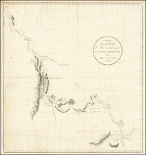
The Track of Ernest Shackleton's Ill-Fated Voyage. One of the First Detailed Maps of His Journey.
Fantastically detailed and well-executed map showing the track of the "Endurance" and the subsequent trials faced by Sir Ernest Shackleton and his men during their famous voyage to the South Sea, published shortly after their return to England.
The map shows the known coastlines of Antarctica at the time, alongside the recorded position of Shackleton and his men along the way. The treacherous boat journey across to South Georgia is marked, as are the four separate relief attempts to reach the men that Shackleton left behind on Elephant Island.
The map is rarer than a reduced size version of the map that removes some information. This map was issued in a number of formats, both in a pamphlet published to accompany Shackleton's lecture series delivered upon his return and in a London-published book.
Shackleton and the Endurance
In 1914, Sir Ernest Shackleton embarked on an ambitious expedition to traverse Antarctica from sea to sea via the South Pole. The expedition's ship, the Endurance, set sail from South Georgia Island, but the journey took a perilous turn when the ship became trapped in pack ice in the Weddell Sea. Despite the crew's best efforts to free the vessel, the ice's relentless pressure eventually crushed the Endurance, forcing Shackleton and his men to abandon ship. They salvaged what they could and set up camp on the floating ice, marking the beginning of a harrowing ordeal that would test the limits of human resilience.
For months, the crew drifted aimlessly on ice floes, battling extreme cold, hunger, and despair. Shackleton's leadership was instrumental during this period; he maintained morale and instilled a sense of purpose among his men. Realizing that rescue was improbable unless they took action, Shackleton and a small team set out in a lifeboat to reach South Georgia Island, nearly 800 miles away, to seek help. After an arduous 16-day journey across the treacherous Southern Ocean, they reached the island and then had to cross its mountainous terrain to reach a whaling station.
The rescue of the remaining crew members was no less miraculous. Shackleton returned to the ice-bound men with a Chilean tugboat, the Yelcho, on August 30, 1916, more than a year and a half after the Endurance was first trapped. Astonishingly, all of the expedition members survived. The story of the Endurance expedition remains a testament to human grit and the indomitable spirit of adventure.
Edward Stanford (1827-1904) was a prominent British mapmaker and publisher. A native of Holborn in the heart of London, Edward was apprenticed to a printer and stationer at the age of 14. After his first master died, he worked with several others, including Trelawny W. Saunders of Charing Cross. Saunders oversaw young Edward’s early career, ensuring that he became a Fellow of the Royal Geographical Society. Associations with the Society eventually brought Sanders much business and gave him a reputation as a publisher of explorers. As testament to this reputation, the Stanford Range in British Columbia was named for him by John Palliser.
Stanford briefly partnered with Saunders in 1852 before striking out on his own in 1853. He was an agent for the Ordnance Survey, the Admiralty, the Geological Survey, the Trigonometrical Survey of India, and the India Office. He also controlled the maps of the Society for the Diffusion of Useful Knowledge, another lucrative source of income. In 1857, Stanford founded his namesake Geographical Establishment, with Saunders and A. K. Johnston as engravers. Thereafter, Stanford was known for his “library maps”, particularly those of Africa and Asia.
Addresses and Years of Operation:
- 6 Charing Cross, London (1848): Edward Stanford's initial place of employment at Trelawney Saunders' shop.
- 7 and 8 Charing Cross, London (1853): Stanford expanded his shop to these addresses.
- 55 Charing Cross, London (1873): The shop moved to this larger location.
- 12-14 Long Acre, London (1873): Site of the new print works and current flagship store.
- 7 Mercer Walk, London (2019): Stanfords moved to this address, continuing its legacy.
Stanford's work with Chief Cartographer John Bolton, including the 1858 Library Map of Europe, positioned the company as a leader in quality cartography during a time of exploration and colonialism. Their 1862 Library Map of London earned acclaim from the Royal Geographical Society. With the business thriving, Stanford purchased Staunton & Son in 1877 and, upon retiring in 1885, handed over the reins to his son, Edward Stanford II.
As sole agents for Ordnance Survey Maps, the company's influence and reputation grew, culminating in the Stanford’s London Atlas Of Universal Geography, which was presented to Queen Victoria in 1887. The transition into the 20th century saw further integration of retail, print, and cartographic operations at Long Acre.
During World War I, Stanford's became an essential publisher for the War Office. Edward Fraser Stanford took over in 1917, steering the company through the interwar period and innovations, such as the world’s smallest maps in 1922 and the Daily Mail Motor Road Map in 1926.
Withstanding a bombing in WWII, the company continued under the stewardship of John Keith Stanford and was sold to George Philip & Son in 1947. As it adapted to the digital age, Stanfords received the Ordnance Survey Premier Partner status in 2007 and ventured into online mapping and data services.
Stanfords, now an icon for travellers and explorers, has maintained its cultural relevance and retail success well into the 21st century, underpinned by a legacy of entrepreneurial spirit and commitment to cartographic excellence.
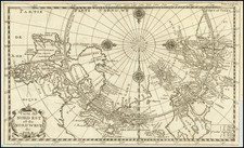
![[Rare Second State] Poli Arctici, et Circumiacentium Terrarum Descriptio Novissima](https://storage.googleapis.com/raremaps/img/small/93127.jpg)