


|
||

|

|
|

|
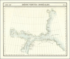
The Most Comprehensive Wall Map of Arctic Exploration of the 19th Century.
Published Less Than a Decade Before the North Pole was Reached.
Vincenz von Haardt's 1898 large format map of the North Polar regions, published in Vienna by E. Hoelzel, is a significant chromolithographed wall map chronicling the history of Arctic exploration with remarkable detail. Starting with Martin Frobisher's voyages in the late 16th century (1576-78), the map traces the evolution of Arctic exploration over more than three centuries, leading up to contemporary expeditions of its time.
The map systematically records the progress of Arctic exploration, from the early endeavors of explorers like Willem Barents in 1594 and Henry Hudson in 1607, through the 18th and 19th centuries with voyages by explorers such as Alexander Mackenzie in 1789 and Sir Edward Parry in the early 1820s. The 19th century is particularly well-represented, highlighting pivotal expeditions like those of John Franklin in 1826 and Frederick William Beechey.
The map also includes the path taken Peary in 1891-92 and 1895. The late 19th century is marked by Fridtjof Nansen and Otto Sverdrup's expeditions in 1895, as well as other journeys like those of the "Balaena" in 1897 and the "Helgoland" in 1898, demonstrating the continued fervor for polar exploration. The map also illustrates Andrée's Arctic balloon expedition of 1897, a failed Swedish attempt to reach the North Pole, which resulted in the deaths of all three explorers.
Incorporating extensive scientific data, the map reflects the empirical and intellectual traditions of the time, influenced by figures like the Humboldt brothers. It features detailed scientific observations such as ice coverage, ocean currents, temperature variations, and magnetic fields, offering a comprehensive view of the North Polar regions as understood at the brink of the 20th century.
Insets
The map includes eight thematic insets, clockwise from upper right: Precipitation; Isotherms in July; Magnetic Conditions; Isobars and winds in July.
Selection of Labeled Voyages
- "Fox" 1858
- "Rescue" 1851
- "Resolute" 1855
- Frobisher 1576-78
- Hall 1860-62
- "Hope" 1897
- Parry 1822
- Parry 1821
- Dease & Simpson, August 1839
- Collinson, Winter 1852-53
- Wynniat, May 1851
- McClure, Winter 1850-51
- Richardson, August 1848
- Mackenzie, July 1789
- Pullen, August 1849
- Collinson, Winter 1853-54
- Franklin, August 1826
- Kellett, July 1849
- Berry, ("Rodgers"), 19 September 1881
- Onatzewitsch, 14 August 1876
- Kotzebue 1816
- Wrangell, March 1823
- De Long, August 1867
- Kosmin, July 1823
- Anjou, April 1822
- Untergang, "Jeannette", 13 June 1881
- Nansen and Johannesen, 7 April 1895
- Sverdrup, 16, 1895 ("Fram")
- Weyprecht and Payer, 1873-74
- Jackson, 1894-96
- "Balaena" 1897
- Leigh Smith 1881
- "Helgoland", 1898
- Pike, ("Victoria") 1897
- Kukenthal 1889
- Hudson 1607
- Barents, July 1594
Rarity
OCLC records a handful of institutional examples dated to 1898, 1899, or 1900. The map is very rare on the market, this being the first time we have handled it (1992-2024).
We previously offered the 1895 Antarctic companion map in 2013.
Vinzenz Haardt von Hartenthurn was a cartographer and military geographer.
Haardt was born in Iglau (Jihlava, Moravia) on August 13, 1843, and died in Vienna on August 1, 1914. His father was a general major.
Vinzenz finished his studies at the Theresian Military Academy and the Imperial Royal War School in Vienna. He participated in the 1866 campaign in Italy, fought against the insurrection in Cattaro in 1869, and became a captain in the General Staff. By 1872, he was a professor at the Technical Military Academy and from 1877 to 1896, he was the scientific head at Eduard Hölzel. In 1897, he became the head of the 1st department at the Military Geographical Institute, was made a government councilor in 1896, and a ministerial councilor in 1912. He attended numerous international geographical congresses and the international earth map conference in London in 1909 and in Paris in 1913.
His work focused on cartography and school geography, contributing to atlas and wall maps, and writing explanations for map works. Notably, he worked on the wall map of the Alps and the text for the portable edition of the "Geograph. Charakterbilder" along with Fr. Umlauft. His research on the history of cartography, especially on the cartography of the Balkan Peninsula in the 19th and 20th centuries, the development of cartography in Austria, and the Military Geographical Institute, are of lasting value. He was also the editor of the "Mitteilungen der Geographischen Gesellschaft Wien" in 1884 and 1885.
His works include several editions of the Kozenn Atlas, the Geographic Atlas of the Austro-Hungarian Monarchy in 1883, a wall map of the Alps in 1882, an overview map of the ethnographic conditions of Asia in 1887, a South Pole map in 1895, and a hand map of Bosnia and Herzegovina in 1907, among others. He also authored significant writings on the division of the Alps, the development of cartography in Austria, and the military geographical Institute, as well as other contributions to the understanding of military topographical work in Europe and the cartography of the Balkan Peninsula.

![Originalkarte zur Ubersicht des Standpunktes neuester Polarforschungen bis Ende September 1874. [with:] Provisiorische Skizze von Franz Joseph Land entdeckt von der 2. Oster.-ungar. Nordpolar-Expedition 1873 & 1874](https://storage.googleapis.com/raremaps/img/small/98481.jpg)
![Navigatio ac Itinerarium Iohannis Hugonis Linscotani in Orientalem Sive Lusitanorum Indiam... [Voyage and Journey of Jan Huygen van Linschoten to the Eastern, or Portuguese India...]](https://storage.googleapis.com/raremaps/img/small/93009.jpg)
![[ Antarctic Regions - Shackleton ] British Antarctic Expedition 1907 -- General Map showing the Explorations and Surveys of the Expedition 1907-1909](https://storage.googleapis.com/raremaps/img/small/99613.jpg)