The item illustrated and described below is sold, but we
have another example in stock. To view the example which
is currently being offered for sale, click the
"View Details" button below.


|
||

|

|
|

|
Stock# 94911
Description
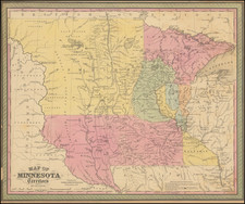
First State, With a County Configuration That Lasted For Less Than Two Years.
Important early map of Minnesota Territory, including some of the eastern Dakotas, from the 1850 edition of Cowperthwait's Universal Atlas.
The map is based largely on the works of Nicollet and Pope, and includes extensive notes on early exploration and topography throughout.
This early edition is recognizable for the massive Pembina and Dahkota Counties in the west and south and only a total of 9 counties in the entire Territory.
An essential map for Minnesota and Dakota collectors.