|
||

|

|
|

|
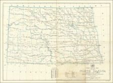
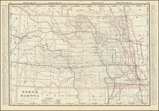
A rare, separately issued pocket map of the Dakota Territory.
Though established in 1861, the Dakota Territory did not experience a rush of settlement until the 1870s. By then the wars with the eastern Sioux had concluded, and the surviving native Americans were being pushed into reservations; much land had been surveyed by the Federal Government; and the railroad had arrived. With cheap land available, security ensured, and rail access to the Great Lakes and from thence to eastern markets established, settlers began to pour in. In 1889 the Territory was divided into the new states of North and South Dakota.
This large and impressive map conveys a vivid picture of the Dakotas a work in progress. The most prominent features are the county lines and the grid of ranges and townships imposed on the eastern half of the Territory by the Survey of Public Lands. Superimposed on this are existing and proposed towns, forts, military and Indian reservations, the Territorial Highway, and the Northern Pacific and other rail lines. The map also provides a great deal of topographical information, including river systems, buttes, the Badlands, and "submarine fossils" in Cheyenne County.
Rarity
The map is rare, with OCLC locating only four in institutional collections and Antique Map Price Record listing two examples offered for sale in the past 30 years (one each of the 1881 and 1882 variants). Cram also published a New Sectional Map of Dakota in 1878, though that map was on a smaller scale.
We are aware of editions of this map published in 1880, 1881, 1882, and 1885.
George F. Cram (1842-1928), or George Franklin Cram, was an American mapmaker and businessman. During the Civil War, Cram served under General William Tecumseh Sherman and participated in his March to the Sea. His letters of that time are now important sources for historians of the Civil War. In 1867, Cram and his uncle, Rufus Blanchard, began the company known by their names in Evanston, Illinois.
Two years later, Cram became sole proprietor and the company was henceforth known as George F. Cram Co. Specializing in atlases, Cram was one of the first American companies to publish a world atlas. One of their most famous products was the Unrivaled Atlas of the World, in print from the 1880s to the 1950s.
Cram died in 1928, seven years after he had merged the business with that of a customer, E.A. Peterson. The new company still bore Cram’s name. Four years later, the Cram Company began to make globes, a branch of the business that would continue until 2012, when the company ceased to operate. For the final several decades of the company’s existence it was controlled by the Douthit family, who sold it just before the company was shuttered.
![[ State of Lincoln! ] British Columbia and the North West Territory](https://storage.googleapis.com/raremaps/img/small/60518.jpg)