|
||

|

|
|

|
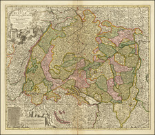
Interesting early 18th Century map of southeastern Germany and contiguous parts of Austria, Bohemia, Moravia and northern Italy.
Despite its size, the map is valuable historical document that provides a glimpse into the intricate political divisions and territorial holdings of the region during that period, delineating the various regions and shedding light on the political landscape of "Southern Germany" in the 18th century.
One of the prominent regions depicted on the map is Bavaria, which was under the rule of the Electors of Bavaria. Bavaria, located in the southeastern part of present-day Germany, was a significant and influential territory during this period. Known for its rich cultural heritage and thriving cities such as Munich, Bavaria was renowned for its architectural achievements, including the grand palaces and churches that still stand today.
The Archbishopric of Salzburg is another region identified on the map. Situated in present-day Austria, the Archbishopric of Salzburg was a prince-bishopric, meaning that the ruling archbishop held both ecclesiastical and secular powers. Salzburg was known for its stunning baroque architecture, particularly the Salzburg Cathedral and the Hohensalzburg Fortress, which still captivate visitors with their grandeur.
The map also includes several territories under the rule of the House of Austria, namely Bohemia, Moravia, Austria, Styria, Carinthia, and Carniola. Bohemia, located in the present-day Czech Republic, was a kingdom within the Holy Roman Empire. It was a culturally diverse region, known for its historic capital city, Prague, with its iconic Charles Bridge and Prague Castle.
Moravia, also part of the present-day Czech Republic, was an important region known for its fertile lands and vibrant agricultural industry. Austria, the core territory of the House of Austria, encompassed areas such as Vienna, which served as the imperial capital and a center of culture and arts.
Styria, Carinthia, and Carniola were regions located in present-day Austria and Slovenia. Styria was known for its natural beauty, with picturesque landscapes and charming towns. Carinthia was renowned for its stunning lakes, including Lake Wörthersee, and its alpine scenery. Carniola, which is part of present-day Slovenia, featured a mix of beautiful mountainous landscapes, charming towns, and historical sites.
The Bishopric of Brixen, Trent, and the County of Tyrol were also represented on the map. These territories, situated in present-day Italy, were under the ecclesiastical rule of the bishops and prince-bishops. The County of Tyrol, in particular, was known for its breathtaking mountain ranges, including the majestic Dolomites, making it a popular destination for outdoor enthusiasts.
Herman Moll (c. 1654-1732) was one of the most important London mapmakers in the first half of the eighteenth century. Moll was probably born in Bremen, Germany, around 1654. He moved to London to escape the Scanian Wars. His earliest work was as an engraver for Moses Pitt on the production of the English Atlas, a failed work which landed Pitt in debtor's prison. Moll also engraved for Sir Jonas Moore, Grenville Collins, John Adair, and the Seller & Price firm. He published his first original maps in the early 1680s and had set up his own shop by the 1690s.
Moll's work quickly helped him become a member of a group which congregated at Jonathan's Coffee House at Number 20 Exchange Alley, Cornhill, where speculators met to trade stock. Moll's circle included the scientist Robert Hooke, the archaeologist William Stuckley, the authors Jonathan Swift and Daniel Defoe, and the intellectually-gifted pirates William Dampier, Woodes Rogers and William Hacke. From these contacts, Moll gained a great deal of privileged information that was included in his maps.
Over the course of his career, he published dozens of geographies, atlases, and histories, not to mention numerous sheet maps. His most famous works are Atlas Geographus, a monthly magazine that ran from 1708 to 1717, and The World Described (1715-54). He also frequently made maps for books, including those of Dampier’s publications and Swift’s Gulliver’s Travels. Moll died in 1732. It is likely that his plates passed to another contemporary, Thomas Bowles, after this death.
![Hungaria Ungarn [Hungary, Slovakia, Northern Croatia and Northern Serbia]](https://storage.googleapis.com/raremaps/img/small/76437mp2.jpg)