|
||

|

|
|

|
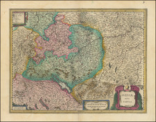
Fine original hand-color example of the De Jode map of eastern Switzerland and adjacent regions.
The map is oriented with west at the top. It is bounded by Bern, Switzerland in the west; Ulm, Germany, in the east; it goes almost as far north as Strasbourg, and in the south touches the northern tip of Lake Como (Lacus Larius). The map shows Zurich and Lake Constance in the center.
Below the scale of miles is a text line reading Gerardus de Jode excudebat Anno Do. 1569, likely the first year of publication of the map as a separately issued sheet.
The map is one of a series of three maps engraved by De Jode showing the course of the Rhine.
Gerard De Jode (1509-1591) was a pre-eminent mapmaker in the late seventeenth century, a time when the Dutch dominated the map trade. He was known for his many maps, some of which featured in Speculum Orbis Terrae (first edition Antwerp: 1578). Although never as successful as Ortelius’ Theatrum, the Speculum did get republished in a second edition in 1593, two years after De Jode’s death, by Arnold Coninx, and included this map. After his death, Gerard’s son, Cornelis (1568-1600), and his wife, Paschina, ran the shop. Unfortunately, Cornelis died young in 1600, aged only 32, and the stock and plates were sold to the publisher Joan Baptista Vrients.